You are here: Home > Network List > US - United States National Seismic Network Stations List
> Station DUG Dugway, Tooele County, Utah, USA > Earthquake Result Viewer
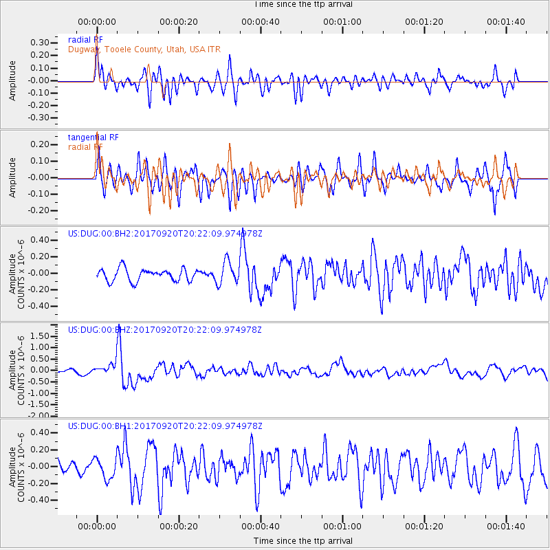
DUG Dugway, Tooele County, Utah, USA - Earthquake Result Viewer
*The percent match for this event was below the threshold and hence no stack was calculated.
| Earthquake location: |
Vanuatu Islands |
| Earthquake latitude/longitude: |
-18.8/169.1 |
| Earthquake time(UTC): |
2017/09/20 (263) 20:09:49 GMT |
| Earthquake Depth: |
200 km |
| Earthquake Magnitude: |
6.4 mww |
| Earthquake Catalog/Contributor: |
NEIC PDE/us |
|
| Network: |
US United States National Seismic Network |
| Station: |
DUG Dugway, Tooele County, Utah, USA |
| Lat/Lon: |
40.19 N/112.81 W |
| Elevation: |
1477 m |
|
| Distance: |
93.2 deg |
| Az: |
48.65 deg |
| Baz: |
248.186 deg |
| Ray Param: |
$rayparam |
*The percent match for this event was below the threshold and hence was not used in the summary stack. |
|
| Radial Match: |
67.44738 % |
| Radial Bump: |
400 |
| Transverse Match: |
63.90689 % |
| Transverse Bump: |
400 |
| SOD ConfigId: |
2341311 |
| Insert Time: |
2017-10-04 21:02:42.695 +0000 |
| GWidth: |
2.5 |
| Max Bumps: |
400 |
| Tol: |
0.001 |
|
Signal To Noise
| Channel | StoN | STA | LTA |
| US:DUG:00:BHZ:20170920T20:22:09.974978Z | 2.3041472 | 2.6075088E-7 | 1.1316589E-7 |
| US:DUG:00:BH1:20170920T20:22:09.974978Z | 1.5549959 | 1.2374036E-7 | 7.9576004E-8 |
| US:DUG:00:BH2:20170920T20:22:09.974978Z | 1.8678812 | 1.3851995E-7 | 7.415887E-8 |
| Arrivals |
| Ps | |
| PpPs | |
| PsPs/PpSs | |


