You are here: Home > Network List > MY - Malaysian National Seismic Network Stations List
> Station SBM Sibu > Earthquake Result Viewer
SBM Sibu - Earthquake Result Viewer
| Earthquake location: |
East Of Kuril Islands |
| Earthquake latitude/longitude: |
46.9/155.2 |
| Earthquake time(UTC): |
2009/01/15 (015) 17:49:39 GMT |
| Earthquake Depth: |
36 km |
| Earthquake Magnitude: |
6.9 MB, 7.5 MS, 7.4 MW, 7.4 MW |
| Earthquake Catalog/Contributor: |
WHDF/NEIC |
|
| Network: |
MY Malaysian National Seismic Network |
| Station: |
SBM Sibu |
| Lat/Lon: |
2.45 N/112.21 E |
| Elevation: |
237 m |
|
| Distance: |
57.8 deg |
| Az: |
233.544 deg |
| Baz: |
33.537 deg |
| Ray Param: |
0.06319285 |
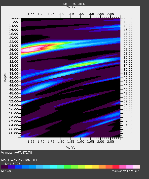
| Estimated Moho Depth: |
25.25 km |
| Estimated Crust Vp/Vs: |
1.64 |
| Assumed Crust Vp: |
6.343 km/s |
| Estimated Crust Vs: |
3.862 km/s |
| Estimated Crust Poisson's Ratio: |
0.21 |
|
| Radial Match: |
97.47178 % |
| Radial Bump: |
234 |
| Transverse Match: |
93.66008 % |
| Transverse Bump: |
400 |
| SOD ConfigId: |
2834 |
| Insert Time: |
2010-03-09 03:52:26.845 +0000 |
| GWidth: |
2.5 |
| Max Bumps: |
400 |
| Tol: |
0.001 |
|

Signal To Noise
| Channel | StoN | STA | LTA |
| MY:SBM: :BHN:20090115T17:58:56.119011Z | 52.715603 | 1.0831271E-5 | 2.0546614E-7 |
| MY:SBM: :BHE:20090115T17:58:56.119011Z | 17.065924 | 3.5365488E-6 | 2.0722868E-7 |
| MY:SBM: :BHZ:20090115T17:58:56.119011Z | 13.233794 | 2.6772695E-6 | 2.023055E-7 |
| Arrivals |
| Ps | 2.7 SECOND |
| PpPs | 10.0 SECOND |
| PsPs/PpSs | 13 SECOND |


