You are here: Home > Network List > US - United States National Seismic Network Stations List
> Station MSO Missoula, Montana, USA > Earthquake Result Viewer
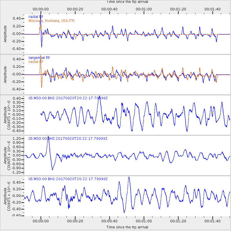
MSO Missoula, Montana, USA - Earthquake Result Viewer
*The percent match for this event was below the threshold and hence no stack was calculated.
| Earthquake location: |
Vanuatu Islands |
| Earthquake latitude/longitude: |
-18.8/169.1 |
| Earthquake time(UTC): |
2017/09/20 (263) 20:09:49 GMT |
| Earthquake Depth: |
200 km |
| Earthquake Magnitude: |
6.4 mww |
| Earthquake Catalog/Contributor: |
NEIC PDE/us |
|
| Network: |
US United States National Seismic Network |
| Station: |
MSO Missoula, Montana, USA |
| Lat/Lon: |
46.83 N/113.94 W |
| Elevation: |
1264 m |
|
| Distance: |
94.9 deg |
| Az: |
42.177 deg |
| Baz: |
247.873 deg |
| Ray Param: |
$rayparam |
*The percent match for this event was below the threshold and hence was not used in the summary stack. |
|
| Radial Match: |
59.76541 % |
| Radial Bump: |
400 |
| Transverse Match: |
44.60657 % |
| Transverse Bump: |
400 |
| SOD ConfigId: |
2341311 |
| Insert Time: |
2017-10-04 21:02:51.535 +0000 |
| GWidth: |
2.5 |
| Max Bumps: |
400 |
| Tol: |
0.001 |
|
Signal To Noise
| Channel | StoN | STA | LTA |
| US:MSO:00:BHZ:20170920T20:22:17.79999Z | 3.9376235 | 5.6624395E-7 | 1.4380348E-7 |
| US:MSO:00:BH1:20170920T20:22:17.79999Z | 1.2739438 | 1.595473E-7 | 1.252389E-7 |
| US:MSO:00:BH2:20170920T20:22:17.79999Z | 2.1628604 | 2.356099E-7 | 1.089344E-7 |
| Arrivals |
| Ps | |
| PpPs | |
| PsPs/PpSs | |


