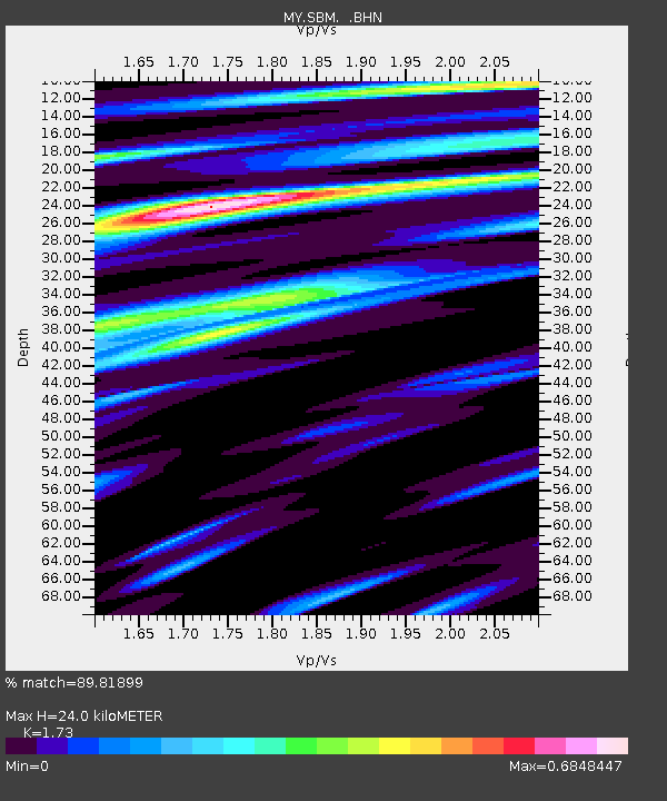
SBM Sibu - Earthquake Result Viewer

Earthquake location: Near West Coast Of Honshu, Japan
Earthquake latitude/longitude: 37.5/138.4
Earthquake time(UTC): 2007/07/16 (197) 01:13:22 GMT
Earthquake Depth: 12 km
Earthquake Magnitude: 6.5 MB, 6.4 MS, 6.6 MW, 6.5 MW
Earthquake Catalog/Contributor: WHDF/NEIC
Network: MY Malaysian National Seismic Network
Station: SBM Sibu
Lat/Lon: 2.45 N/112.21 E
Elevation: 237 m
Distance: 42.4 deg
Az: 220.894 deg
Baz: 31.393 deg
Ray Param: 0.07318058
Estimated Moho Depth: 24.0 km
Estimated Crust Vp/Vs: 1.73
Assumed Crust Vp: 6.343 km/s
Estimated Crust Vs: 3.667 km/s
Estimated Crust Poisson's Ratio: 0.25
Radial Match: 89.81899 %
Radial Bump: 400
Transverse Match: 72.17367 %
Transverse Bump: 400
SOD ConfigId: 2564
Insert Time: 2010-03-09 03:52:59.870 +0000
GWidth: 2.5
Max Bumps: 400
Tol: 0.001

Signal To Noise

ChannelStoNSTALTA
MY:SBM: :BHN:20070716T01:20:45.919011Z17.1454288.081288E-74.7133778E-8
MY:SBM: :BHE:20070716T01:20:45.919011Z8.1650165.865906E-77.184194E-8
MY:SBM: :BHZ:20070716T01:20:45.919011Z44.9672362.0088683E-64.4674042E-8
Arrivals
Ps3.0 SECOND
PpPs9.7 SECOND
PsPs/PpSs13 SECOND