You are here: Home > Network List > MY - Malaysian National Seismic Network Stations List
> Station SBM Sibu > Earthquake Result Viewer
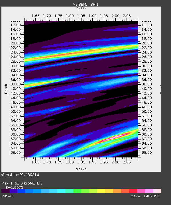
SBM Sibu - Earthquake Result Viewer
| Earthquake location: |
Solomon Islands |
| Earthquake latitude/longitude: |
-8.6/157.5 |
| Earthquake time(UTC): |
2007/04/02 (092) 13:53:07 GMT |
| Earthquake Depth: |
11 km |
| Earthquake Magnitude: |
5.6 MB, 5.2 MS |
| Earthquake Catalog/Contributor: |
WHDF/NEIC |
|
| Network: |
MY Malaysian National Seismic Network |
| Station: |
SBM Sibu |
| Lat/Lon: |
2.45 N/112.21 E |
| Elevation: |
237 m |
|
| Distance: |
46.5 deg |
| Az: |
281.601 deg |
| Baz: |
104.139 deg |
| Ray Param: |
0.07061508 |
| Estimated Moho Depth: |
61.0 km |
| Estimated Crust Vp/Vs: |
2.00 |
| Assumed Crust Vp: |
6.343 km/s |
| Estimated Crust Vs: |
3.176 km/s |
| Estimated Crust Poisson's Ratio: |
0.33 |
|
| Radial Match: |
91.480316 % |
| Radial Bump: |
375 |
| Transverse Match: |
73.132256 % |
| Transverse Bump: |
400 |
| SOD ConfigId: |
2564 |
| Insert Time: |
2010-03-09 03:53:13.144 +0000 |
| GWidth: |
2.5 |
| Max Bumps: |
400 |
| Tol: |
0.001 |
|

Signal To Noise
| Channel | StoN | STA | LTA |
| MY:SBM: :BHN:20070402T14:01:03.618013Z | 0.6733637 | 5.7154583E-8 | 8.487922E-8 |
| MY:SBM: :BHE:20070402T14:01:03.618013Z | 2.059977 | 1.7551052E-7 | 8.520023E-8 |
| MY:SBM: :BHZ:20070402T14:01:03.618013Z | 2.2187798 | 3.5355686E-7 | 1.5934742E-7 |
| Arrivals |
| Ps | 10 SECOND |
| PpPs | 27 SECOND |
| PsPs/PpSs | 37 SECOND |


