You are here: Home > Network List > CC - Cascade Chain Volcano Monitoring Stations List
> Station HUSB The Husband > Earthquake Result Viewer
HUSB The Husband - Earthquake Result Viewer
| Earthquake location: |
Northern Chile |
| Earthquake latitude/longitude: |
-20.4/-69.1 |
| Earthquake time(UTC): |
2020/12/06 (341) 16:47:41 GMT |
| Earthquake Depth: |
98 km |
| Earthquake Magnitude: |
6.1 mww |
| Earthquake Catalog/Contributor: |
NEIC PDE/us |
|
| Network: |
CC Cascade Chain Volcano Monitoring |
| Station: |
HUSB The Husband |
| Lat/Lon: |
44.12 N/121.85 W |
| Elevation: |
2038 m |
|
| Distance: |
80.3 deg |
| Az: |
324.435 deg |
| Baz: |
130.746 deg |
| Ray Param: |
0.048171155 |
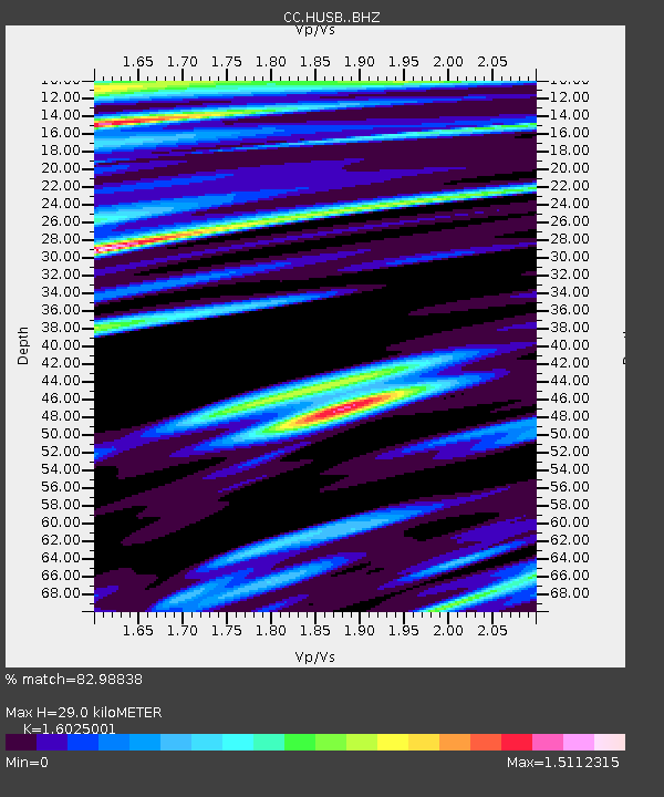
| Estimated Moho Depth: |
29.0 km |
| Estimated Crust Vp/Vs: |
1.60 |
| Assumed Crust Vp: |
6.597 km/s |
| Estimated Crust Vs: |
4.117 km/s |
| Estimated Crust Poisson's Ratio: |
0.18 |
|
| Radial Match: |
82.98838 % |
| Radial Bump: |
400 |
| Transverse Match: |
62.162186 % |
| Transverse Bump: |
400 |
| SOD ConfigId: |
23341671 |
| Insert Time: |
2020-12-20 17:51:50.475 +0000 |
| GWidth: |
2.5 |
| Max Bumps: |
400 |
| Tol: |
0.001 |
|

Signal To Noise
| Channel | StoN | STA | LTA |
| CC:HUSB: :BHZ:20201206T16:59:10.959994Z | 4.891781 | 1.7753712E-6 | 3.6292946E-7 |
| CC:HUSB: :BHN:20201206T16:59:10.959994Z | 1.0246464 | 1.1245238E-6 | 1.097475E-6 |
| CC:HUSB: :BHE:20201206T16:59:10.959994Z | 2.1145198 | 1.3515283E-6 | 6.391656E-7 |
| Arrivals |
| Ps | 2.7 SECOND |
| PpPs | 11 SECOND |
| PsPs/PpSs | 14 SECOND |


