You are here: Home > Network List > CI - Caltech Regional Seismic Network Stations List
> Station SWS Sam W. Stewart, Westmorland, CA, USA > Earthquake Result Viewer
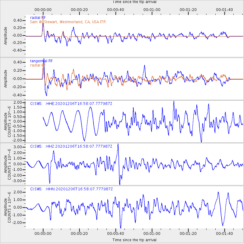
SWS Sam W. Stewart, Westmorland, CA, USA - Earthquake Result Viewer
*The percent match for this event was below the threshold and hence no stack was calculated.
| Earthquake location: |
Northern Chile |
| Earthquake latitude/longitude: |
-20.4/-69.1 |
| Earthquake time(UTC): |
2020/12/06 (341) 16:47:41 GMT |
| Earthquake Depth: |
98 km |
| Earthquake Magnitude: |
6.1 mww |
| Earthquake Catalog/Contributor: |
NEIC PDE/us |
|
| Network: |
CI Caltech Regional Seismic Network |
| Station: |
SWS Sam W. Stewart, Westmorland, CA, USA |
| Lat/Lon: |
32.94 N/115.80 W |
| Elevation: |
140 m |
|
| Distance: |
69.3 deg |
| Az: |
319.14 deg |
| Baz: |
133.124 deg |
| Ray Param: |
$rayparam |
*The percent match for this event was below the threshold and hence was not used in the summary stack. |
|
| Radial Match: |
55.848415 % |
| Radial Bump: |
394 |
| Transverse Match: |
54.862343 % |
| Transverse Bump: |
400 |
| SOD ConfigId: |
23341671 |
| Insert Time: |
2020-12-20 17:54:06.390 +0000 |
| GWidth: |
2.5 |
| Max Bumps: |
400 |
| Tol: |
0.001 |
|
Signal To Noise
| Channel | StoN | STA | LTA |
| CI:SWS: :HHZ:20201206T16:58:07.777987Z | 2.923048 | 1.0682256E-6 | 3.6544918E-7 |
| CI:SWS: :HHN:20201206T16:58:07.777987Z | 1.3436294 | 5.558756E-7 | 4.13712E-7 |
| CI:SWS: :HHE:20201206T16:58:07.777987Z | 1.1466461 | 9.375607E-7 | 8.176548E-7 |
| Arrivals |
| Ps | |
| PpPs | |
| PsPs/PpSs | |


