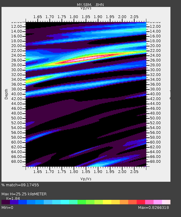
SBM Sibu - Earthquake Result Viewer

Earthquake location: Kuril Islands
Earthquake latitude/longitude: 46.5/153.2
Earthquake time(UTC): 2006/10/01 (274) 09:06:02 GMT
Earthquake Depth: 19 km
Earthquake Magnitude: 6.1 MB, 6.4 MS, 6.6 MW, 6.5 MW
Earthquake Catalog/Contributor: WHDF/NEIC
Network: MY Malaysian National Seismic Network
Station: SBM Sibu
Lat/Lon: 2.45 N/112.21 E
Elevation: 237 m
Distance: 56.5 deg
Az: 231.84 deg
Baz: 32.952 deg
Ray Param: 0.06406861
Estimated Moho Depth: 25.25 km
Estimated Crust Vp/Vs: 1.84
Assumed Crust Vp: 6.343 km/s
Estimated Crust Vs: 3.447 km/s
Estimated Crust Poisson's Ratio: 0.29
Radial Match: 89.17455 %
Radial Bump: 400
Transverse Match: 62.041904 %
Transverse Bump: 400
SOD ConfigId: 2665
Insert Time: 2010-03-09 03:54:25.018 +0000
GWidth: 2.5
Max Bumps: 400
Tol: 0.001

Signal To Noise

ChannelStoNSTALTA
MY:SBM: :BHN:20061001T09:15:12.220024Z2.08883834.406392E-72.109494E-7
MY:SBM: :BHE:20061001T09:15:12.220024Z2.48209243.8800582E-71.5632206E-7
MY:SBM: :BHZ:20061001T09:15:12.220024Z9.2260211.3694381E-61.4843215E-7
Arrivals
Ps3.5 SECOND
PpPs11 SECOND
PsPs/PpSs14 SECOND