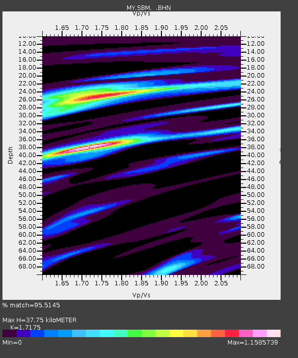
SBM Sibu - Earthquake Result Viewer

Earthquake location: Andreanof Islands, Aleutian Is.
Earthquake latitude/longitude: 51.2/-179.3
Earthquake time(UTC): 2006/07/08 (189) 20:40:00 GMT
Earthquake Depth: 22 km
Earthquake Magnitude: 6.2 MB, 6.4 MS, 6.6 MW, 6.6 MW
Earthquake Catalog/Contributor: WHDF/NEIC
Network: MY Malaysian National Seismic Network
Station: SBM Sibu
Lat/Lon: 2.45 N/112.21 E
Elevation: 237 m
Distance: 74.7 deg
Az: 254.471 deg
Baz: 37.341 deg
Ray Param: 0.052123785
Estimated Moho Depth: 37.75 km
Estimated Crust Vp/Vs: 1.72
Assumed Crust Vp: 6.343 km/s
Estimated Crust Vs: 3.693 km/s
Estimated Crust Poisson's Ratio: 0.24
Radial Match: 95.5145 %
Radial Bump: 295
Transverse Match: 88.554 %
Transverse Bump: 400
SOD ConfigId: 2665
Insert Time: 2010-03-09 03:54:37.195 +0000
GWidth: 2.5
Max Bumps: 400
Tol: 0.001

Signal To Noise

ChannelStoNSTALTA
MY:SBM: :BHN:20060708T20:51:07.719014Z2.44220971.8244027E-77.470295E-8
MY:SBM: :BHE:20060708T20:51:07.719014Z2.75431131.6678045E-76.05525E-8
MY:SBM: :BHZ:20060708T20:51:07.719014Z8.7320198.0530674E-79.222457E-8
Arrivals
Ps4.4 SECOND
PpPs16 SECOND
PsPs/PpSs20 SECOND