You are here: Home > Network List > IU - Global Seismograph Network (GSN - IRIS/USGS) Stations List
> Station CTAO Charters Towers, Australia > Earthquake Result Viewer
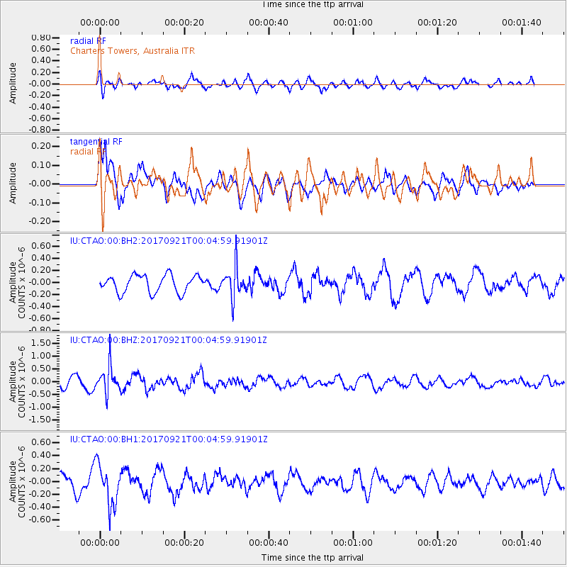
CTAO Charters Towers, Australia - Earthquake Result Viewer
*The percent match for this event was below the threshold and hence no stack was calculated.
| Earthquake location: |
Java, Indonesia |
| Earthquake latitude/longitude: |
-6.1/113.0 |
| Earthquake time(UTC): |
2017/09/20 (263) 23:59:24 GMT |
| Earthquake Depth: |
589 km |
| Earthquake Magnitude: |
5.7 Mww |
| Earthquake Catalog/Contributor: |
NEIC PDE/us |
|
| Network: |
IU Global Seismograph Network (GSN - IRIS/USGS) |
| Station: |
CTAO Charters Towers, Australia |
| Lat/Lon: |
20.09 S/146.25 E |
| Elevation: |
357 m |
|
| Distance: |
35.1 deg |
| Az: |
116.413 deg |
| Baz: |
288.652 deg |
| Ray Param: |
$rayparam |
*The percent match for this event was below the threshold and hence was not used in the summary stack. |
|
| Radial Match: |
69.251114 % |
| Radial Bump: |
400 |
| Transverse Match: |
65.59947 % |
| Transverse Bump: |
400 |
| SOD ConfigId: |
2341311 |
| Insert Time: |
2017-10-05 01:18:05.738 +0000 |
| GWidth: |
2.5 |
| Max Bumps: |
400 |
| Tol: |
0.001 |
|
Signal To Noise
| Channel | StoN | STA | LTA |
| IU:CTAO:00:BHZ:20170921T00:04:59.91901Z | 2.7838984 | 5.2907103E-7 | 1.9004682E-7 |
| IU:CTAO:00:BH1:20170921T00:04:59.91901Z | 3.2806363 | 3.176479E-7 | 9.682508E-8 |
| IU:CTAO:00:BH2:20170921T00:04:59.91901Z | 1.8112801 | 2.606686E-7 | 1.4391401E-7 |
| Arrivals |
| Ps | |
| PpPs | |
| PsPs/PpSs | |


