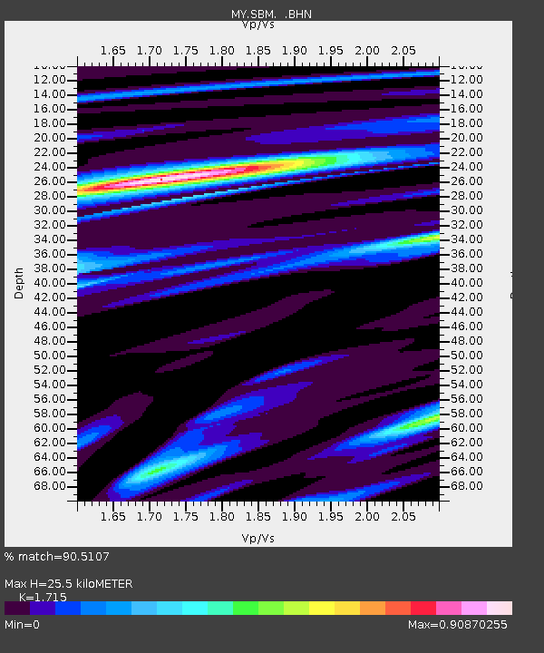
SBM Sibu - Earthquake Result Viewer

Earthquake location: Loyalty Islands
Earthquake latitude/longitude: -20.3/168.8
Earthquake time(UTC): 2008/04/19 (110) 05:58:42 GMT
Earthquake Depth: 14 km
Earthquake Magnitude: 5.7 MB, 6.2 MS, 6.3 MW, 6.2 MW
Earthquake Catalog/Contributor: WHDF/NEIC
Network: MY Malaysian National Seismic Network
Station: SBM Sibu
Lat/Lon: 2.45 N/112.21 E
Elevation: 237 m
Distance: 59.9 deg
Az: 285.384 deg
Baz: 115.043 deg
Ray Param: 0.06189442
Estimated Moho Depth: 25.5 km
Estimated Crust Vp/Vs: 1.72
Assumed Crust Vp: 6.343 km/s
Estimated Crust Vs: 3.699 km/s
Estimated Crust Poisson's Ratio: 0.24
Radial Match: 90.5107 %
Radial Bump: 400
Transverse Match: 67.560974 %
Transverse Bump: 400
SOD ConfigId: 2504
Insert Time: 2010-03-09 03:55:17.536 +0000
GWidth: 2.5
Max Bumps: 400
Tol: 0.001

Signal To Noise

ChannelStoNSTALTA
MY:SBM: :BHN:20080419T06:08:16.27002Z22.823751.2937011E-65.6682236E-8
MY:SBM: :BHE:20080419T06:08:16.27002Z1.05880121.9957457E-71.8849107E-7
MY:SBM: :BHZ:20080419T06:08:16.27002Z2.42439586.9880605E-72.8823928E-7
Arrivals
Ps3.0 SECOND
PpPs10 SECOND
PsPs/PpSs13 SECOND