You are here: Home > Network List > TX - Texas Seismological Network Stations List
> Station MB02 Rankin > Earthquake Result Viewer
MB02 Rankin - Earthquake Result Viewer
| Earthquake location: |
Northern Chile |
| Earthquake latitude/longitude: |
-20.4/-69.1 |
| Earthquake time(UTC): |
2020/12/06 (341) 16:47:41 GMT |
| Earthquake Depth: |
98 km |
| Earthquake Magnitude: |
6.1 mww |
| Earthquake Catalog/Contributor: |
NEIC PDE/us |
|
| Network: |
TX Texas Seismological Network |
| Station: |
MB02 Rankin |
| Lat/Lon: |
31.20 N/102.04 W |
| Elevation: |
768 m |
|
| Distance: |
60.2 deg |
| Az: |
327.544 deg |
| Baz: |
144.019 deg |
| Ray Param: |
0.061392352 |
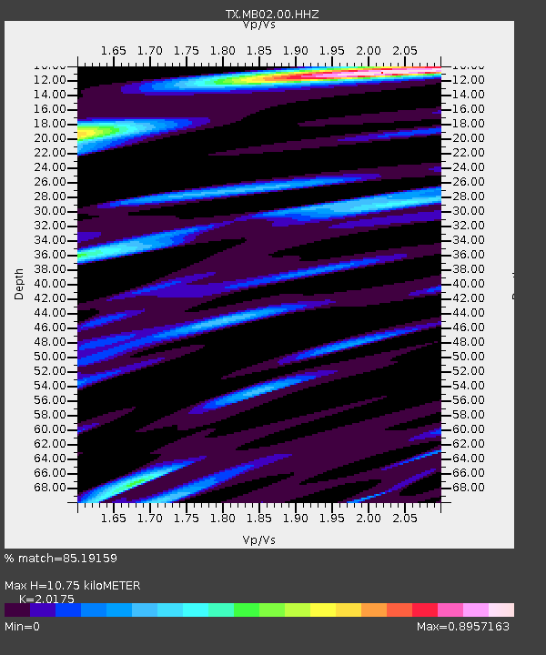
| Estimated Moho Depth: |
10.75 km |
| Estimated Crust Vp/Vs: |
2.02 |
| Assumed Crust Vp: |
6.121 km/s |
| Estimated Crust Vs: |
3.034 km/s |
| Estimated Crust Poisson's Ratio: |
0.34 |
|
| Radial Match: |
85.19159 % |
| Radial Bump: |
400 |
| Transverse Match: |
73.95455 % |
| Transverse Bump: |
400 |
| SOD ConfigId: |
23341671 |
| Insert Time: |
2020-12-20 18:10:25.420 +0000 |
| GWidth: |
2.5 |
| Max Bumps: |
400 |
| Tol: |
0.001 |
|

Signal To Noise
| Channel | StoN | STA | LTA |
| TX:MB02:00:HHZ:20201206T16:57:09.220004Z | 10.158276 | 6.184355E-7 | 6.087997E-8 |
| TX:MB02:00:HH1:20201206T16:57:09.220004Z | 1.7971826 | 1.3938377E-7 | 7.755682E-8 |
| TX:MB02:00:HH2:20201206T16:57:09.220004Z | 3.9033985 | 2.7693E-7 | 7.0945866E-8 |
| Arrivals |
| Ps | 1.9 SECOND |
| PpPs | 5.1 SECOND |
| PsPs/PpSs | 7.0 SECOND |


