You are here: Home > Network List > US - United States National Seismic Network Stations List
> Station DGMT Dagmar, Montana, USA > Earthquake Result Viewer
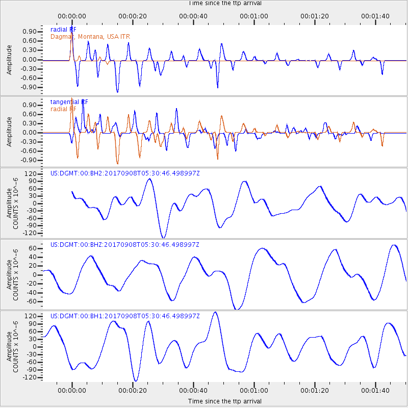
DGMT Dagmar, Montana, USA - Earthquake Result Viewer
*The percent match for this event was below the threshold and hence no stack was calculated.
| Earthquake location: |
Near Coast Of Oaxaca, Mexico |
| Earthquake latitude/longitude: |
15.2/-94.6 |
| Earthquake time(UTC): |
2017/09/08 (251) 05:24:36 GMT |
| Earthquake Depth: |
49 km |
| Earthquake Magnitude: |
5.2 mb |
| Earthquake Catalog/Contributor: |
NEIC PDE/us |
|
| Network: |
US United States National Seismic Network |
| Station: |
DGMT Dagmar, Montana, USA |
| Lat/Lon: |
48.47 N/104.20 W |
| Elevation: |
0.0 m |
|
| Distance: |
34.1 deg |
| Az: |
348.583 deg |
| Baz: |
163.311 deg |
| Ray Param: |
$rayparam |
*The percent match for this event was below the threshold and hence was not used in the summary stack. |
|
| Radial Match: |
50.511753 % |
| Radial Bump: |
400 |
| Transverse Match: |
55.18164 % |
| Transverse Bump: |
400 |
| SOD ConfigId: |
2341311 |
| Insert Time: |
2017-10-05 06:51:27.499 +0000 |
| GWidth: |
2.5 |
| Max Bumps: |
400 |
| Tol: |
0.001 |
|
Signal To Noise
| Channel | StoN | STA | LTA |
| US:DGMT:00:BHZ:20170908T05:30:46.498997Z | 1.4768969 | 2.8833028E-5 | 1.952271E-5 |
| US:DGMT:00:BH1:20170908T05:30:46.498997Z | 1.9577979 | 7.6638404E-5 | 3.9145205E-5 |
| US:DGMT:00:BH2:20170908T05:30:46.498997Z | 2.9189274 | 8.7943496E-5 | 3.0128702E-5 |
| Arrivals |
| Ps | |
| PpPs | |
| PsPs/PpSs | |


