You are here: Home > Network List > US - United States National Seismic Network Stations List
> Station HAWA Hanford, Washington, USA > Earthquake Result Viewer
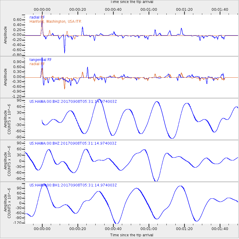
HAWA Hanford, Washington, USA - Earthquake Result Viewer
*The percent match for this event was below the threshold and hence no stack was calculated.
| Earthquake location: |
Near Coast Of Oaxaca, Mexico |
| Earthquake latitude/longitude: |
15.2/-94.6 |
| Earthquake time(UTC): |
2017/09/08 (251) 05:24:36 GMT |
| Earthquake Depth: |
49 km |
| Earthquake Magnitude: |
5.2 mb |
| Earthquake Catalog/Contributor: |
NEIC PDE/us |
|
| Network: |
US United States National Seismic Network |
| Station: |
HAWA Hanford, Washington, USA |
| Lat/Lon: |
46.39 N/119.53 W |
| Elevation: |
364 m |
|
| Distance: |
37.4 deg |
| Az: |
331.31 deg |
| Baz: |
137.961 deg |
| Ray Param: |
$rayparam |
*The percent match for this event was below the threshold and hence was not used in the summary stack. |
|
| Radial Match: |
72.25622 % |
| Radial Bump: |
246 |
| Transverse Match: |
62.62457 % |
| Transverse Bump: |
388 |
| SOD ConfigId: |
2341311 |
| Insert Time: |
2017-10-05 06:51:31.502 +0000 |
| GWidth: |
2.5 |
| Max Bumps: |
400 |
| Tol: |
0.001 |
|
Signal To Noise
| Channel | StoN | STA | LTA |
| US:HAWA:00:BHZ:20170908T05:31:14.974003Z | 1.2378142 | 3.8494472E-5 | 3.109875E-5 |
| US:HAWA:00:BH1:20170908T05:31:14.974003Z | 2.2198012 | 1.0501535E-4 | 4.730845E-5 |
| US:HAWA:00:BH2:20170908T05:31:14.974003Z | 2.9471545 | 8.95665E-5 | 3.039084E-5 |
| Arrivals |
| Ps | |
| PpPs | |
| PsPs/PpSs | |


