You are here: Home > Network List > CN - Canadian National Seismograph Network Stations List
> Station INK INUVIK, NT > Earthquake Result Viewer
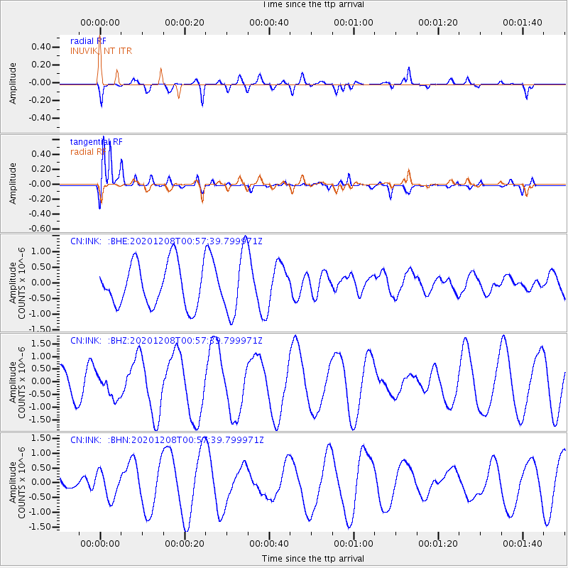
INK INUVIK, NT - Earthquake Result Viewer
*The percent match for this event was below the threshold and hence no stack was calculated.
| Earthquake location: |
Volcano Islands, Japan Region |
| Earthquake latitude/longitude: |
22.5/144.8 |
| Earthquake time(UTC): |
2020/12/08 (343) 00:47:22 GMT |
| Earthquake Depth: |
10 km |
| Earthquake Magnitude: |
5.3 mww |
| Earthquake Catalog/Contributor: |
NEIC PDE/us |
|
| Network: |
CN Canadian National Seismograph Network |
| Station: |
INK INUVIK, NT |
| Lat/Lon: |
68.31 N/133.53 W |
| Elevation: |
44 m |
|
| Distance: |
66.2 deg |
| Az: |
23.704 deg |
| Baz: |
271.128 deg |
| Ray Param: |
$rayparam |
*The percent match for this event was below the threshold and hence was not used in the summary stack. |
|
| Radial Match: |
37.955597 % |
| Radial Bump: |
306 |
| Transverse Match: |
81.911476 % |
| Transverse Bump: |
400 |
| SOD ConfigId: |
23341671 |
| Insert Time: |
2020-12-22 01:53:43.077 +0000 |
| GWidth: |
2.5 |
| Max Bumps: |
400 |
| Tol: |
0.001 |
|
Signal To Noise
| Channel | StoN | STA | LTA |
| CN:INK: :BHZ:20201208T00:57:39.799971Z | 0.649029 | 4.4033408E-7 | 6.7845053E-7 |
| CN:INK: :BHN:20201208T00:57:39.799971Z | 0.90015846 | 4.490961E-7 | 4.989078E-7 |
| CN:INK: :BHE:20201208T00:57:39.799971Z | 1.515281 | 1.0268682E-6 | 6.776751E-7 |
| Arrivals |
| Ps | |
| PpPs | |
| PsPs/PpSs | |


