You are here: Home > Network List > US - United States National Seismic Network Stations List
> Station HAWA Hanford, Washington, USA > Earthquake Result Viewer
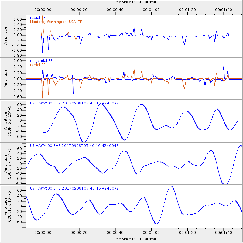
HAWA Hanford, Washington, USA - Earthquake Result Viewer
*The percent match for this event was below the threshold and hence no stack was calculated.
| Earthquake location: |
Near Coast Of Oaxaca, Mexico |
| Earthquake latitude/longitude: |
15.3/-94.4 |
| Earthquake time(UTC): |
2017/09/08 (251) 05:33:37 GMT |
| Earthquake Depth: |
46 km |
| Earthquake Magnitude: |
5.2 mb |
| Earthquake Catalog/Contributor: |
NEIC PDE/us |
|
| Network: |
US United States National Seismic Network |
| Station: |
HAWA Hanford, Washington, USA |
| Lat/Lon: |
46.39 N/119.53 W |
| Elevation: |
364 m |
|
| Distance: |
37.5 deg |
| Az: |
331.102 deg |
| Baz: |
137.638 deg |
| Ray Param: |
$rayparam |
*The percent match for this event was below the threshold and hence was not used in the summary stack. |
|
| Radial Match: |
57.943848 % |
| Radial Bump: |
400 |
| Transverse Match: |
65.56084 % |
| Transverse Bump: |
254 |
| SOD ConfigId: |
2341311 |
| Insert Time: |
2017-10-05 06:54:11.005 +0000 |
| GWidth: |
2.5 |
| Max Bumps: |
400 |
| Tol: |
0.001 |
|
Signal To Noise
| Channel | StoN | STA | LTA |
| US:HAWA:00:BHZ:20170908T05:40:16.424004Z | 0.83840567 | 2.1774484E-5 | 2.5971298E-5 |
| US:HAWA:00:BH1:20170908T05:40:16.424004Z | 0.8178904 | 2.510407E-5 | 3.069368E-5 |
| US:HAWA:00:BH2:20170908T05:40:16.424004Z | 1.4123433 | 6.1914834E-5 | 4.3838376E-5 |
| Arrivals |
| Ps | |
| PpPs | |
| PsPs/PpSs | |


