You are here: Home > Network List > NE - New England Seismic Network Stations List
> Station HNH Hanover, NH, USA > Earthquake Result Viewer
HNH Hanover, NH, USA - Earthquake Result Viewer
| Earthquake location: |
Off Coast Of Northern California |
| Earthquake latitude/longitude: |
40.4/-126.8 |
| Earthquake time(UTC): |
2017/09/22 (265) 19:50:15 GMT |
| Earthquake Depth: |
11 km |
| Earthquake Magnitude: |
5.6 Mw |
| Earthquake Catalog/Contributor: |
NEIC PDE/us |
|
| Network: |
NE New England Seismic Network |
| Station: |
HNH Hanover, NH, USA |
| Lat/Lon: |
43.71 N/72.29 W |
| Elevation: |
180 m |
|
| Distance: |
40.0 deg |
| Az: |
66.73 deg |
| Baz: |
284.722 deg |
| Ray Param: |
0.07463444 |
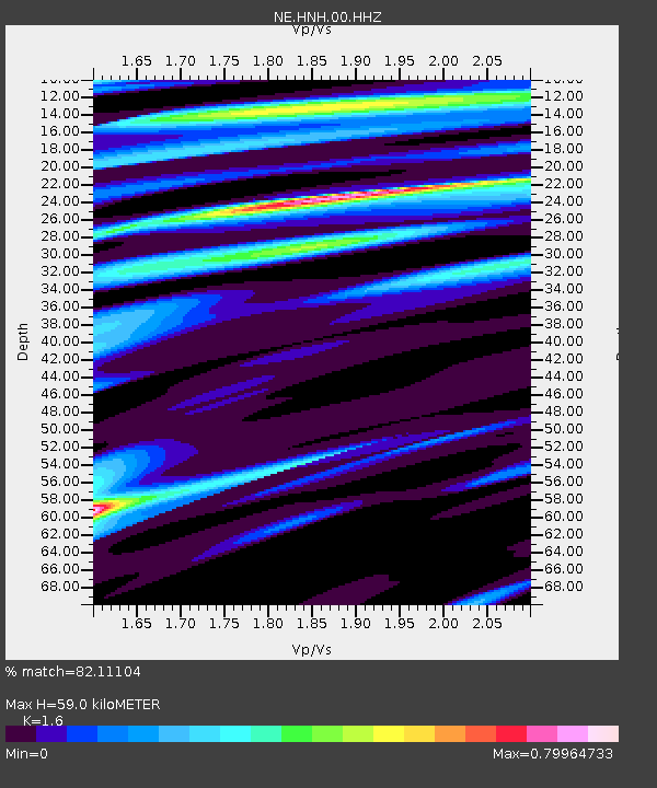
| Estimated Moho Depth: |
59.0 km |
| Estimated Crust Vp/Vs: |
1.60 |
| Assumed Crust Vp: |
6.419 km/s |
| Estimated Crust Vs: |
4.012 km/s |
| Estimated Crust Poisson's Ratio: |
0.18 |
|
| Radial Match: |
82.11104 % |
| Radial Bump: |
400 |
| Transverse Match: |
54.61706 % |
| Transverse Bump: |
400 |
| SOD ConfigId: |
2360691 |
| Insert Time: |
2017-10-06 22:12:09.890 +0000 |
| GWidth: |
2.5 |
| Max Bumps: |
400 |
| Tol: |
0.001 |
|

Signal To Noise
| Channel | StoN | STA | LTA |
| NE:HNH:00:HHZ:20170922T19:57:19.003999Z | 2.745837 | 1.9089032E-6 | 6.95199E-7 |
| NE:HNH:00:HH1:20170922T19:57:19.003999Z | 1.1271894 | 6.293693E-7 | 5.583527E-7 |
| NE:HNH:00:HH2:20170922T19:57:19.003999Z | 1.6687937 | 1.1134721E-6 | 6.672317E-7 |
| Arrivals |
| Ps | 6.0 SECOND |
| PpPs | 22 SECOND |
| PsPs/PpSs | 28 SECOND |


