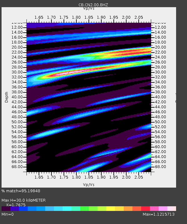
CN2 Changchun,Jilin Province - Earthquake Result Viewer

Earthquake location: Andreanof Islands, Aleutian Is.
Earthquake latitude/longitude: 51.6/-174.0
Earthquake time(UTC): 2016/03/12 (072) 18:06:45 GMT
Earthquake Depth: 19 km
Earthquake Magnitude: 6.3 MWW, 6.1 MB, 6.2 MWB, 6.3 MWC, 6.4 MWC, 6.4 MI
Earthquake Catalog/Contributor: NEIC PDE/NEIC COMCAT
Network: CB China National Seismic Network
Station: CN2 Changchun,Jilin Province
Lat/Lon: 43.48 N/125.26 E
Elevation: 223 m
Distance: 40.7 deg
Az: 283.279 deg
Baz: 56.578 deg
Ray Param: 0.07421413
Estimated Moho Depth: 30.0 km
Estimated Crust Vp/Vs: 1.77
Assumed Crust Vp: 6.459 km/s
Estimated Crust Vs: 3.655 km/s
Estimated Crust Poisson's Ratio: 0.26
Radial Match: 95.19948 %
Radial Bump: 351
Transverse Match: 85.68668 %
Transverse Bump: 400
SOD ConfigId: 2361031
Insert Time: 2017-10-09 14:57:58.188 +0000
GWidth: 2.5
Max Bumps: 400
Tol: 0.001

Signal To Noise

ChannelStoNSTALTA
CB:CN2:00:BHZ:20160312T18:13:53.770006Z22.3692151.8943957E-68.468762E-8
CB:CN2:00:BHN:20160312T18:13:53.770006Z10.9033786.28617E-75.7653416E-8
CB:CN2:00:BHE:20160312T18:13:53.770006Z13.9023229.003798E-76.4764706E-8
Arrivals
Ps3.8 SECOND
PpPs12 SECOND
PsPs/PpSs16 SECOND