You are here: Home > Network List > TA - USArray Transportable Network (new EarthScope stations) Stations List
> Station L15K Ungalak Mountain, AK, USA > Earthquake Result Viewer
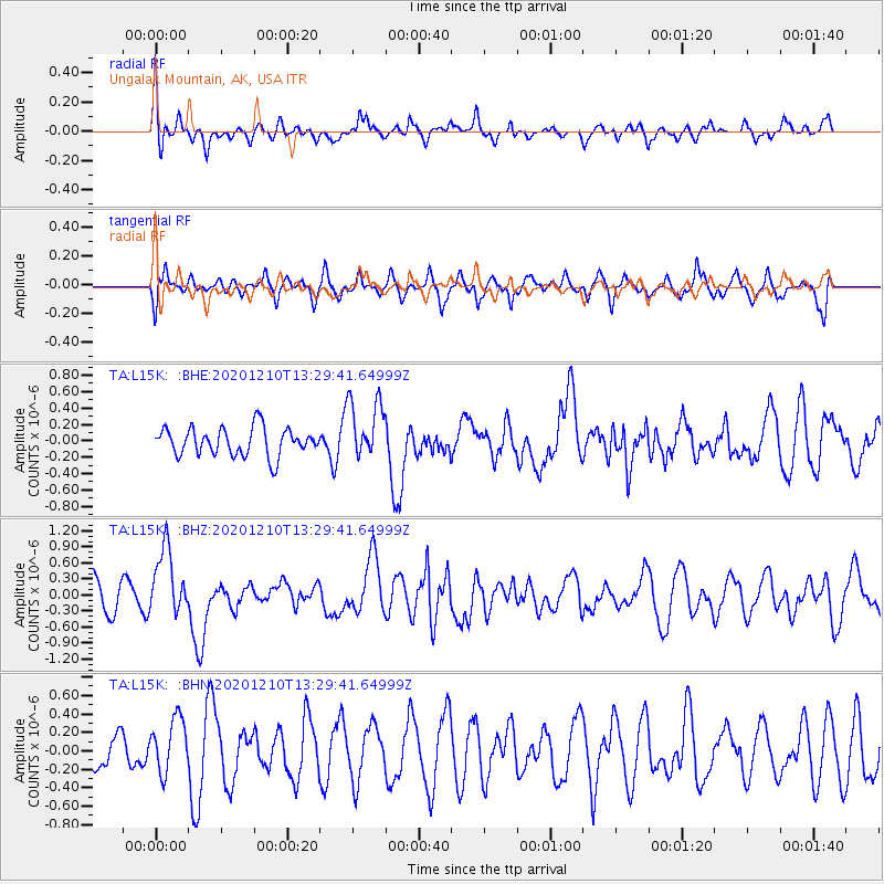
L15K Ungalak Mountain, AK, USA - Earthquake Result Viewer
*The percent match for this event was below the threshold and hence no stack was calculated.
| Earthquake location: |
Taiwan Region |
| Earthquake latitude/longitude: |
24.8/122.0 |
| Earthquake time(UTC): |
2020/12/10 (345) 13:19:58 GMT |
| Earthquake Depth: |
73 km |
| Earthquake Magnitude: |
6.1 mww |
| Earthquake Catalog/Contributor: |
NEIC PDE/us |
|
| Network: |
TA USArray Transportable Network (new EarthScope stations) |
| Station: |
L15K Ungalak Mountain, AK, USA |
| Lat/Lon: |
61.68 N/161.49 W |
| Elevation: |
219 m |
|
| Distance: |
62.1 deg |
| Az: |
31.636 deg |
| Baz: |
270.788 deg |
| Ray Param: |
$rayparam |
*The percent match for this event was below the threshold and hence was not used in the summary stack. |
|
| Radial Match: |
59.069653 % |
| Radial Bump: |
400 |
| Transverse Match: |
58.31251 % |
| Transverse Bump: |
400 |
| SOD ConfigId: |
23341671 |
| Insert Time: |
2020-12-24 14:35:49.943 +0000 |
| GWidth: |
2.5 |
| Max Bumps: |
400 |
| Tol: |
0.001 |
|
Signal To Noise
| Channel | StoN | STA | LTA |
| TA:L15K: :BHZ:20201210T13:29:41.64999Z | 2.0338688 | 6.3564204E-7 | 3.1252856E-7 |
| TA:L15K: :BHN:20201210T13:29:41.64999Z | 1.4902294 | 2.9267713E-7 | 1.9639737E-7 |
| TA:L15K: :BHE:20201210T13:29:41.64999Z | 2.2140248 | 3.756939E-7 | 1.696882E-7 |
| Arrivals |
| Ps | |
| PpPs | |
| PsPs/PpSs | |


