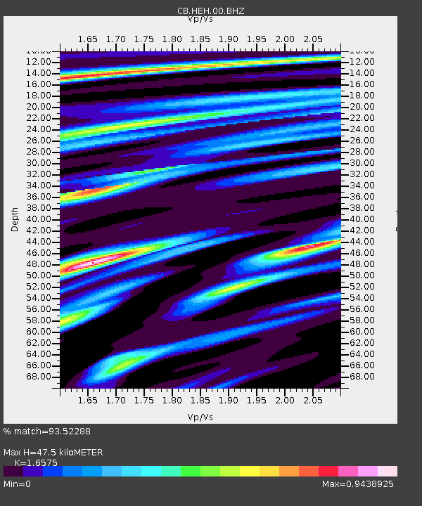
HEH Heihe,Heilongjiang Province - Earthquake Result Viewer
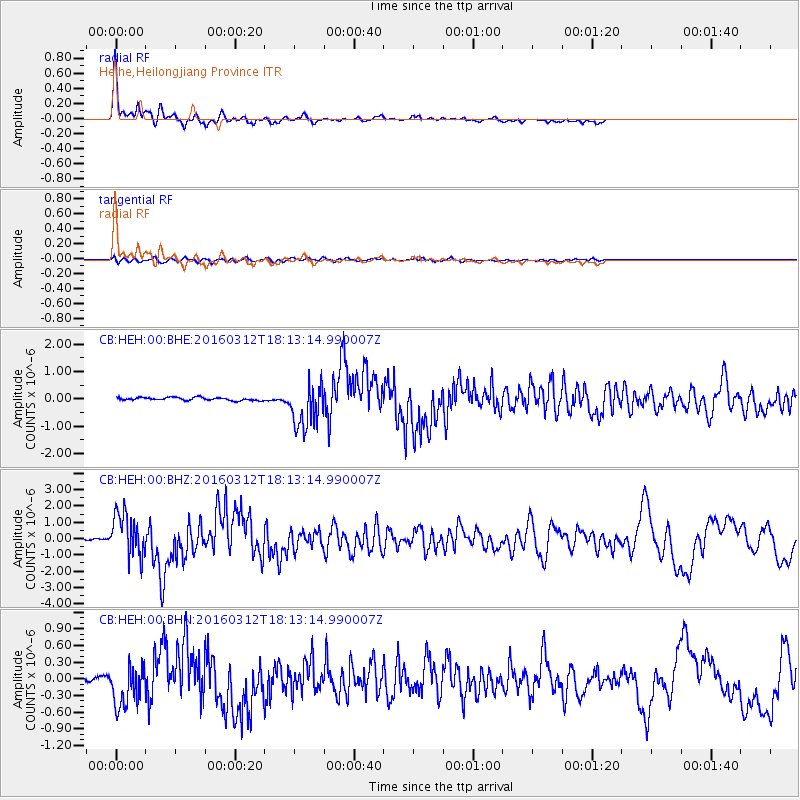
Earthquake location: Andreanof Islands, Aleutian Is.
Earthquake latitude/longitude: 51.6/-174.0
Earthquake time(UTC): 2016/03/12 (072) 18:06:45 GMT
Earthquake Depth: 19 km
Earthquake Magnitude: 6.3 MWW, 6.1 MB, 6.2 MWB, 6.3 MWC, 6.4 MWC, 6.4 MI
Earthquake Catalog/Contributor: NEIC PDE/NEIC COMCAT
Network: CB China National Seismic Network
Station: HEH Heihe,Heilongjiang Province
Lat/Lon: 50.25 N/127.41 E
Elevation: 165 m
Distance: 36.1 deg
Az: 291.62 deg
Baz: 64.691 deg
Ray Param: 0.076844186
Estimated Moho Depth: 47.5 km
Estimated Crust Vp/Vs: 1.66
Assumed Crust Vp: 6.419 km/s
Estimated Crust Vs: 3.873 km/s
Estimated Crust Poisson's Ratio: 0.21
Radial Match: 93.52288 %
Radial Bump: 279
Transverse Match: 62.746555 %
Transverse Bump: 400
SOD ConfigId: 2361031
Insert Time: 2017-10-09 14:58:07.707 +0000
GWidth: 2.5
Max Bumps: 400
Tol: 0.001

Signal To Noise

ChannelStoNSTALTA
CB:HEH:00:BHZ:20160312T18:13:14.990007Z25.5458951.3200595E-65.167404E-8
CB:HEH:00:BHN:20160312T18:13:14.990007Z8.0858653.6250736E-74.483223E-8
CB:HEH:00:BHE:20160312T18:13:14.990007Z15.0565968.1950424E-75.4428252E-8
Arrivals
Ps5.3 SECOND
PpPs18 SECOND
PsPs/PpSs23 SECOND