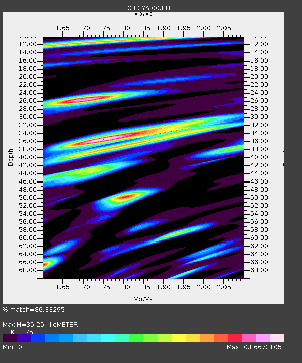
GYA Guiyang,Yunnan Province - Earthquake Result Viewer

Earthquake location: Andreanof Islands, Aleutian Is.
Earthquake latitude/longitude: 51.6/-174.0
Earthquake time(UTC): 2016/03/12 (072) 18:06:45 GMT
Earthquake Depth: 19 km
Earthquake Magnitude: 6.3 MWW, 6.1 MB, 6.2 MWB, 6.3 MWC, 6.4 MWC, 6.4 MI
Earthquake Catalog/Contributor: NEIC PDE/NEIC COMCAT
Network: CB China National Seismic Network
Station: GYA Guiyang,Yunnan Province
Lat/Lon: 26.46 N/106.66 E
Elevation: 1162 m
Distance: 63.3 deg
Az: 279.457 deg
Baz: 43.384 deg
Ray Param: 0.059676684
Estimated Moho Depth: 35.25 km
Estimated Crust Vp/Vs: 1.75
Assumed Crust Vp: 6.113 km/s
Estimated Crust Vs: 3.493 km/s
Estimated Crust Poisson's Ratio: 0.26
Radial Match: 86.33295 %
Radial Bump: 400
Transverse Match: 80.43512 %
Transverse Bump: 400
SOD ConfigId: 2361031
Insert Time: 2017-10-09 14:58:09.655 +0000
GWidth: 2.5
Max Bumps: 400
Tol: 0.001

Signal To Noise

ChannelStoNSTALTA
CB:GYA:00:BHZ:20160312T18:16:41.200029Z12.6951181.1243299E-68.856396E-8
CB:GYA:00:BHN:20160312T18:16:41.200029Z3.6187113.5227723E-79.734881E-8
CB:GYA:00:BHE:20160312T18:16:41.200029Z4.81900644.8533946E-71.007136E-7
Arrivals
Ps4.5 SECOND
PpPs15 SECOND
PsPs/PpSs20 SECOND