You are here: Home > Network List > UW - Pacific Northwest Regional Seismic Network Stations List
> Station HOOD Mt Hood Meadows, OR CREST BB SMO > Earthquake Result Viewer
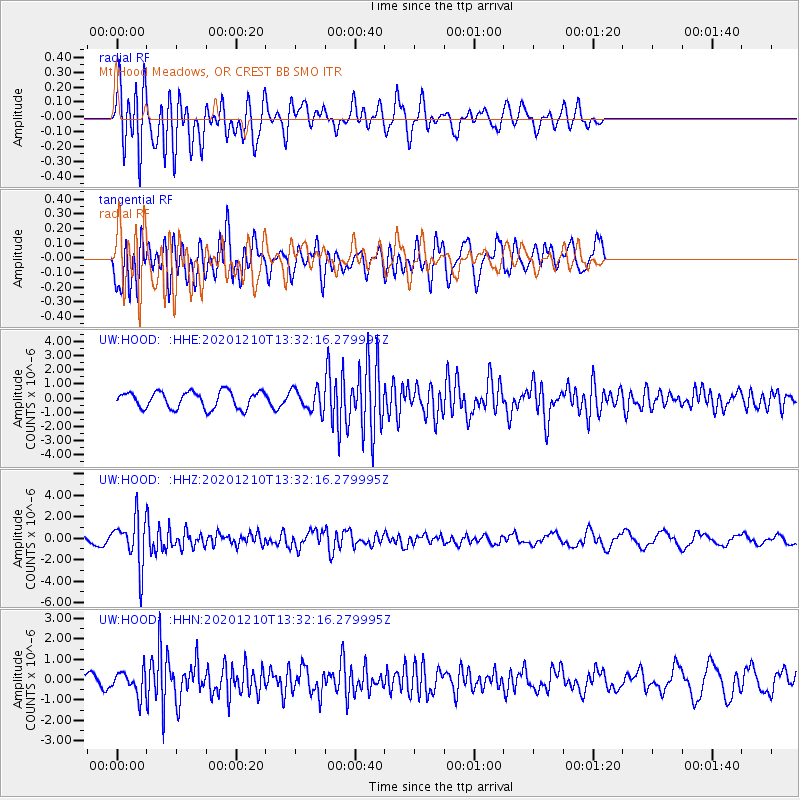
HOOD Mt Hood Meadows, OR CREST BB SMO - Earthquake Result Viewer
*The percent match for this event was below the threshold and hence no stack was calculated.
| Earthquake location: |
Taiwan Region |
| Earthquake latitude/longitude: |
24.8/122.0 |
| Earthquake time(UTC): |
2020/12/10 (345) 13:19:58 GMT |
| Earthquake Depth: |
73 km |
| Earthquake Magnitude: |
6.1 mww |
| Earthquake Catalog/Contributor: |
NEIC PDE/us |
|
| Network: |
UW Pacific Northwest Regional Seismic Network |
| Station: |
HOOD Mt Hood Meadows, OR CREST BB SMO |
| Lat/Lon: |
45.32 N/121.65 W |
| Elevation: |
1520 m |
|
| Distance: |
89.4 deg |
| Az: |
39.221 deg |
| Baz: |
305.433 deg |
| Ray Param: |
$rayparam |
*The percent match for this event was below the threshold and hence was not used in the summary stack. |
|
| Radial Match: |
67.57721 % |
| Radial Bump: |
400 |
| Transverse Match: |
65.749825 % |
| Transverse Bump: |
400 |
| SOD ConfigId: |
23341671 |
| Insert Time: |
2020-12-24 14:37:54.543 +0000 |
| GWidth: |
2.5 |
| Max Bumps: |
400 |
| Tol: |
0.001 |
|
Signal To Noise
| Channel | StoN | STA | LTA |
| UW:HOOD: :HHZ:20201210T13:32:16.279995Z | 6.7417846 | 2.1682697E-6 | 3.2161657E-7 |
| UW:HOOD: :HHN:20201210T13:32:16.279995Z | 1.7261709 | 5.861142E-7 | 3.3954586E-7 |
| UW:HOOD: :HHE:20201210T13:32:16.279995Z | 1.3234612 | 7.772232E-7 | 5.8726556E-7 |
| Arrivals |
| Ps | |
| PpPs | |
| PsPs/PpSs | |


