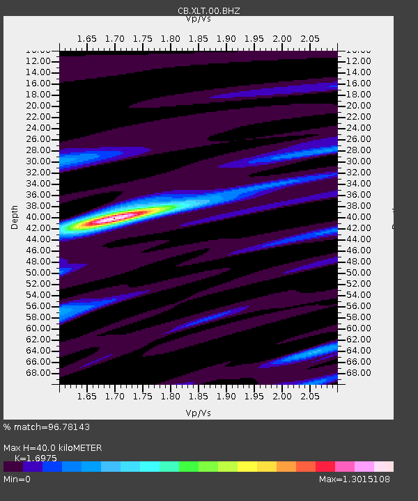
XLT Xilinhaote,Neimeng Province - Earthquake Result Viewer

Earthquake location: Andreanof Islands, Aleutian Is.
Earthquake latitude/longitude: 51.6/-174.0
Earthquake time(UTC): 2016/03/12 (072) 18:06:45 GMT
Earthquake Depth: 19 km
Earthquake Magnitude: 6.3 MWW, 6.1 MB, 6.2 MWB, 6.3 MWC, 6.4 MWC, 6.4 MI
Earthquake Catalog/Contributor: NEIC PDE/NEIC COMCAT
Network: CB China National Seismic Network
Station: XLT Xilinhaote,Neimeng Province
Lat/Lon: 43.90 N/116.08 E
Elevation: 1030 m
Distance: 46.0 deg
Az: 289.261 deg
Baz: 54.608 deg
Ray Param: 0.07090664
Estimated Moho Depth: 40.0 km
Estimated Crust Vp/Vs: 1.70
Assumed Crust Vp: 6.459 km/s
Estimated Crust Vs: 3.805 km/s
Estimated Crust Poisson's Ratio: 0.23
Radial Match: 96.78143 %
Radial Bump: 246
Transverse Match: 88.37404 %
Transverse Bump: 400
SOD ConfigId: 2361031
Insert Time: 2017-10-09 14:58:27.826 +0000
GWidth: 2.5
Max Bumps: 400
Tol: 0.001

Signal To Noise

ChannelStoNSTALTA
CB:XLT:00:BHZ:20160312T18:14:36.129991Z29.4894431.4969636E-65.0762694E-8
CB:XLT:00:BHN:20160312T18:14:36.129991Z11.4972145.784547E-75.0312597E-8
CB:XLT:00:BHE:20160312T18:14:36.129991Z14.3737827.787271E-75.4176912E-8
Arrivals
Ps4.6 SECOND
PpPs16 SECOND
PsPs/PpSs20 SECOND