You are here: Home > Network List > AZ - ANZA Regional Network Stations List
> Station LVA2 AZ.LVA2 > Earthquake Result Viewer
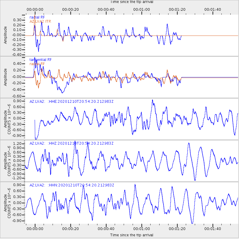
LVA2 AZ.LVA2 - Earthquake Result Viewer
*The percent match for this event was below the threshold and hence no stack was calculated.
| Earthquake location: |
South Of Kermadec Islands |
| Earthquake latitude/longitude: |
-33.0/-179.8 |
| Earthquake time(UTC): |
2020/12/10 (345) 20:42:06 GMT |
| Earthquake Depth: |
83 km |
| Earthquake Magnitude: |
6.0 Mww |
| Earthquake Catalog/Contributor: |
NEIC PDE/us |
|
| Network: |
AZ ANZA Regional Network |
| Station: |
LVA2 AZ.LVA2 |
| Lat/Lon: |
33.35 N/116.56 W |
| Elevation: |
1435 m |
|
| Distance: |
88.8 deg |
| Az: |
48.352 deg |
| Baz: |
228.627 deg |
| Ray Param: |
$rayparam |
*The percent match for this event was below the threshold and hence was not used in the summary stack. |
|
| Radial Match: |
81.00685 % |
| Radial Bump: |
400 |
| Transverse Match: |
54.832535 % |
| Transverse Bump: |
400 |
| SOD ConfigId: |
23341671 |
| Insert Time: |
2020-12-24 21:45:03.049 +0000 |
| GWidth: |
2.5 |
| Max Bumps: |
400 |
| Tol: |
0.001 |
|
Signal To Noise
| Channel | StoN | STA | LTA |
| AZ:LVA2: :HHZ:20201210T20:54:20.212983Z | 2.3336792 | 4.6545605E-7 | 1.9945159E-7 |
| AZ:LVA2: :HHN:20201210T20:54:20.212983Z | 1.0123026 | 4.2687216E-7 | 4.2168432E-7 |
| AZ:LVA2: :HHE:20201210T20:54:20.212983Z | 0.89428645 | 3.1104076E-7 | 3.4780888E-7 |
| Arrivals |
| Ps | |
| PpPs | |
| PsPs/PpSs | |


