You are here: Home > Network List > GE - GEOFON Stations List
> Station PSZ GKKI/GEOFON Station Piszkes, Hungary > Earthquake Result Viewer
PSZ GKKI/GEOFON Station Piszkes, Hungary - Earthquake Result Viewer
| Earthquake location: |
Southern Iran |
| Earthquake latitude/longitude: |
26.8/55.9 |
| Earthquake time(UTC): |
2006/06/28 (179) 21:02:09 GMT |
| Earthquake Depth: |
10 km |
| Earthquake Magnitude: |
5.8 MB, 5.5 MS, 5.8 MW, 5.7 MW |
| Earthquake Catalog/Contributor: |
WHDF/NEIC |
|
| Network: |
GE GEOFON |
| Station: |
PSZ GKKI/GEOFON Station Piszkes, Hungary |
| Lat/Lon: |
47.92 N/19.89 E |
| Elevation: |
940 m |
|
| Distance: |
35.1 deg |
| Az: |
316.523 deg |
| Baz: |
113.922 deg |
| Ray Param: |
0.07741004 |
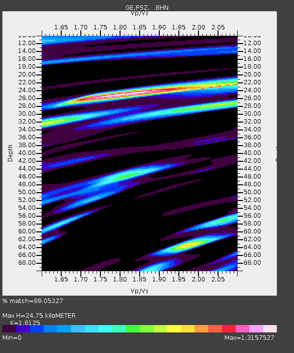
| Estimated Moho Depth: |
24.75 km |
| Estimated Crust Vp/Vs: |
1.81 |
| Assumed Crust Vp: |
6.155 km/s |
| Estimated Crust Vs: |
3.396 km/s |
| Estimated Crust Poisson's Ratio: |
0.28 |
|
| Radial Match: |
89.05327 % |
| Radial Bump: |
400 |
| Transverse Match: |
82.72392 % |
| Transverse Bump: |
400 |
| SOD ConfigId: |
2665 |
| Insert Time: |
2010-03-09 03:59:19.879 +0000 |
| GWidth: |
2.5 |
| Max Bumps: |
400 |
| Tol: |
0.001 |
|

Signal To Noise
| Channel | StoN | STA | LTA |
| GE:PSZ: :BHN:20060628T21:08:31.594012Z | 4.9535856 | 2.1055817E-7 | 4.2506215E-8 |
| GE:PSZ: :BHE:20060628T21:08:31.594012Z | 9.167326 | 3.0094176E-7 | 3.282765E-8 |
| GE:PSZ: :BHZ:20060628T21:08:31.594012Z | 16.344667 | 6.1175456E-7 | 3.742839E-8 |
| Arrivals |
| Ps | 3.5 SECOND |
| PpPs | 11 SECOND |
| PsPs/PpSs | 14 SECOND |


