You are here: Home > Network List > CI - Caltech Regional Seismic Network Stations List
> Station DAN Danby, California, USA > Earthquake Result Viewer
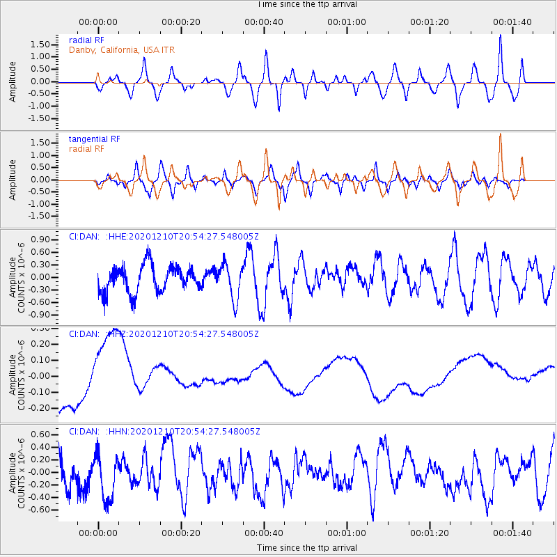
DAN Danby, California, USA - Earthquake Result Viewer
*The percent match for this event was below the threshold and hence no stack was calculated.
| Earthquake location: |
South Of Kermadec Islands |
| Earthquake latitude/longitude: |
-33.0/-179.8 |
| Earthquake time(UTC): |
2020/12/10 (345) 20:42:06 GMT |
| Earthquake Depth: |
83 km |
| Earthquake Magnitude: |
6.0 Mww |
| Earthquake Catalog/Contributor: |
NEIC PDE/us |
|
| Network: |
CI Caltech Regional Seismic Network |
| Station: |
DAN Danby, California, USA |
| Lat/Lon: |
34.64 N/115.38 W |
| Elevation: |
398 m |
|
| Distance: |
90.4 deg |
| Az: |
48.03 deg |
| Baz: |
229.282 deg |
| Ray Param: |
$rayparam |
*The percent match for this event was below the threshold and hence was not used in the summary stack. |
|
| Radial Match: |
65.3489 % |
| Radial Bump: |
400 |
| Transverse Match: |
57.600567 % |
| Transverse Bump: |
400 |
| SOD ConfigId: |
23341671 |
| Insert Time: |
2020-12-24 21:47:27.225 +0000 |
| GWidth: |
2.5 |
| Max Bumps: |
400 |
| Tol: |
0.001 |
|
Signal To Noise
| Channel | StoN | STA | LTA |
| CI:DAN: :HHZ:20201210T20:54:27.548005Z | 0.5975875 | 2.0575399E-7 | 3.4430772E-7 |
| CI:DAN: :HHN:20201210T20:54:27.548005Z | 0.8458508 | 3.6257146E-7 | 4.2864704E-7 |
| CI:DAN: :HHE:20201210T20:54:27.548005Z | 1.3656795 | 4.3439198E-7 | 3.1807755E-7 |
| Arrivals |
| Ps | |
| PpPs | |
| PsPs/PpSs | |


