You are here: Home > Network List > GE - GEOFON Stations List
> Station PSZ GKKI/GEOFON Station Piszkes, Hungary > Earthquake Result Viewer
PSZ GKKI/GEOFON Station Piszkes, Hungary - Earthquake Result Viewer
| Earthquake location: |
Eastern Siberia, Russia |
| Earthquake latitude/longitude: |
60.5/167.5 |
| Earthquake time(UTC): |
2006/04/29 (119) 16:58:06 GMT |
| Earthquake Depth: |
11 km |
| Earthquake Magnitude: |
6.4 MB, 6.6 MS, 6.6 MW, 6.4 MW |
| Earthquake Catalog/Contributor: |
WHDF/NEIC |
|
| Network: |
GE GEOFON |
| Station: |
PSZ GKKI/GEOFON Station Piszkes, Hungary |
| Lat/Lon: |
47.92 N/19.89 E |
| Elevation: |
940 m |
|
| Distance: |
68.8 deg |
| Az: |
337.271 deg |
| Baz: |
16.521 deg |
| Ray Param: |
0.056066584 |
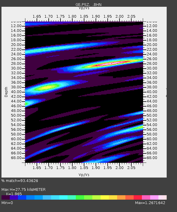
| Estimated Moho Depth: |
27.75 km |
| Estimated Crust Vp/Vs: |
1.97 |
| Assumed Crust Vp: |
6.155 km/s |
| Estimated Crust Vs: |
3.132 km/s |
| Estimated Crust Poisson's Ratio: |
0.33 |
|
| Radial Match: |
93.43626 % |
| Radial Bump: |
344 |
| Transverse Match: |
86.57665 % |
| Transverse Bump: |
400 |
| SOD ConfigId: |
2669 |
| Insert Time: |
2010-03-09 03:59:41.458 +0000 |
| GWidth: |
2.5 |
| Max Bumps: |
400 |
| Tol: |
0.001 |
|

Signal To Noise
| Channel | StoN | STA | LTA |
| GE:PSZ: :BHN:20060429T17:08:39.195Z | 13.383106 | 7.863735E-7 | 5.8758665E-8 |
| GE:PSZ: :BHE:20060429T17:08:39.195Z | 6.92777 | 3.5308852E-7 | 5.0967124E-8 |
| GE:PSZ: :BHZ:20060429T17:08:39.195Z | 35.846333 | 1.7634695E-6 | 4.9195258E-8 |
| Arrivals |
| Ps | 4.5 SECOND |
| PpPs | 13 SECOND |
| PsPs/PpSs | 17 SECOND |


