You are here: Home > Network List > GS - US Geological Survey Networks Stations List
> Station KAN10 Keim Farm > Earthquake Result Viewer
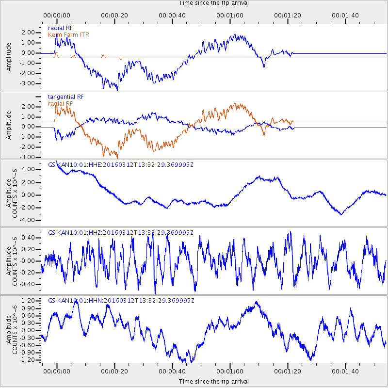
KAN10 Keim Farm - Earthquake Result Viewer
*The percent match for this event was below the threshold and hence no stack was calculated.
| Earthquake location: |
Andreanof Islands, Aleutian Is. |
| Earthquake latitude/longitude: |
51.4/-174.0 |
| Earthquake time(UTC): |
2016/03/12 (072) 13:23:38 GMT |
| Earthquake Depth: |
13 km |
| Earthquake Magnitude: |
5.6 mww |
| Earthquake Catalog/Contributor: |
NEIC PDE/ |
|
| Network: |
GS US Geological Survey Networks |
| Station: |
KAN10 Keim Farm |
| Lat/Lon: |
37.12 N/98.10 W |
| Elevation: |
417 m |
|
| Distance: |
53.8 deg |
| Az: |
73.886 deg |
| Baz: |
311.224 deg |
| Ray Param: |
$rayparam |
*The percent match for this event was below the threshold and hence was not used in the summary stack. |
|
| Radial Match: |
65.7946 % |
| Radial Bump: |
400 |
| Transverse Match: |
53.168358 % |
| Transverse Bump: |
400 |
| SOD ConfigId: |
2361031 |
| Insert Time: |
2017-10-09 15:07:50.630 +0000 |
| GWidth: |
2.5 |
| Max Bumps: |
400 |
| Tol: |
0.001 |
|
Signal To Noise
| Channel | StoN | STA | LTA |
| GS:KAN10:01:HHZ:20160312T13:32:29.369995Z | 1.2632984 | 1.746476E-7 | 1.382473E-7 |
| GS:KAN10:01:HHN:20160312T13:32:29.369995Z | 2.2821066 | 1.3150662E-6 | 5.7625095E-7 |
| GS:KAN10:01:HHE:20160312T13:32:29.369995Z | 1.5839831 | 2.9957598E-6 | 1.8912827E-6 |
| Arrivals |
| Ps | |
| PpPs | |
| PsPs/PpSs | |


