You are here: Home > Network List > US - United States National Seismic Network Stations List
> Station MSO Missoula, Montana, USA > Earthquake Result Viewer
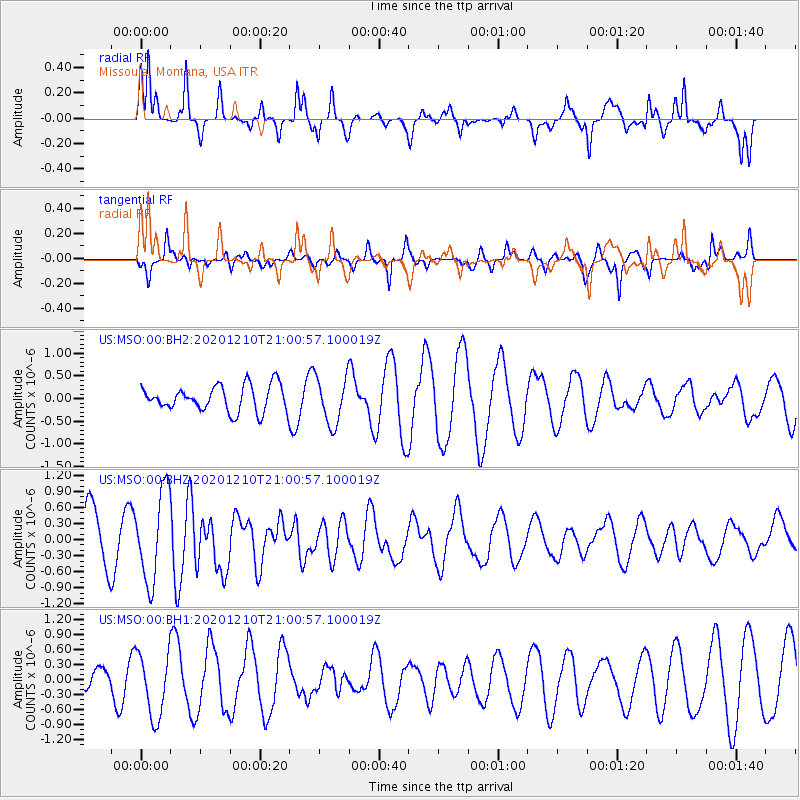
MSO Missoula, Montana, USA - Earthquake Result Viewer
*The percent match for this event was below the threshold and hence no stack was calculated.
| Earthquake location: |
Tonga Islands |
| Earthquake latitude/longitude: |
-17.6/-174.9 |
| Earthquake time(UTC): |
2020/12/10 (345) 20:48:56 GMT |
| Earthquake Depth: |
10 km |
| Earthquake Magnitude: |
5.9 mb |
| Earthquake Catalog/Contributor: |
NEIC PDE/us |
|
| Network: |
US United States National Seismic Network |
| Station: |
MSO Missoula, Montana, USA |
| Lat/Lon: |
46.83 N/113.94 W |
| Elevation: |
1264 m |
|
| Distance: |
84.2 deg |
| Az: |
37.09 deg |
| Baz: |
236.923 deg |
| Ray Param: |
$rayparam |
*The percent match for this event was below the threshold and hence was not used in the summary stack. |
|
| Radial Match: |
67.217445 % |
| Radial Bump: |
311 |
| Transverse Match: |
71.723404 % |
| Transverse Bump: |
353 |
| SOD ConfigId: |
23341671 |
| Insert Time: |
2020-12-24 22:09:16.598 +0000 |
| GWidth: |
2.5 |
| Max Bumps: |
400 |
| Tol: |
0.001 |
|
Signal To Noise
| Channel | StoN | STA | LTA |
| US:MSO:00:BHZ:20201210T21:00:57.100019Z | 1.7741435 | 8.3605073E-7 | 4.7124192E-7 |
| US:MSO:00:BH1:20201210T21:00:57.100019Z | 2.3642633 | 6.385464E-7 | 2.700826E-7 |
| US:MSO:00:BH2:20201210T21:00:57.100019Z | 1.8374687 | 5.246487E-7 | 2.85528E-7 |
| Arrivals |
| Ps | |
| PpPs | |
| PsPs/PpSs | |


