You are here: Home > Network List > GE - GEOFON Stations List
> Station PSZ GKKI/GEOFON Station Piszkes, Hungary > Earthquake Result Viewer
PSZ GKKI/GEOFON Station Piszkes, Hungary - Earthquake Result Viewer
| Earthquake location: |
Taiwan Region |
| Earthquake latitude/longitude: |
24.5/122.0 |
| Earthquake time(UTC): |
2001/06/14 (165) 02:35:25 GMT |
| Earthquake Depth: |
32 km |
| Earthquake Magnitude: |
5.7 MB, 5.6 MS, 5.9 MW, 5.9 MW |
| Earthquake Catalog/Contributor: |
WHDF/NEIC |
|
| Network: |
GE GEOFON |
| Station: |
PSZ GKKI/GEOFON Station Piszkes, Hungary |
| Lat/Lon: |
47.92 N/19.89 E |
| Elevation: |
940 m |
|
| Distance: |
79.8 deg |
| Az: |
318.079 deg |
| Baz: |
64.789 deg |
| Ray Param: |
0.0486444 |
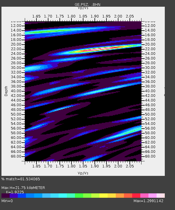
| Estimated Moho Depth: |
21.75 km |
| Estimated Crust Vp/Vs: |
1.92 |
| Assumed Crust Vp: |
6.155 km/s |
| Estimated Crust Vs: |
3.201 km/s |
| Estimated Crust Poisson's Ratio: |
0.31 |
|
| Radial Match: |
81.534065 % |
| Radial Bump: |
400 |
| Transverse Match: |
80.823616 % |
| Transverse Bump: |
400 |
| SOD ConfigId: |
3753 |
| Insert Time: |
2010-03-09 04:00:57.752 +0000 |
| GWidth: |
2.5 |
| Max Bumps: |
400 |
| Tol: |
0.001 |
|

Signal To Noise
| Channel | StoN | STA | LTA |
| GE:PSZ: :BHN:20010614T02:46:59.94501Z | 2.1856658 | 9.372747E-8 | 4.28828E-8 |
| GE:PSZ: :BHE:20010614T02:46:59.94501Z | 2.0669253 | 6.6953625E-8 | 3.239286E-8 |
| GE:PSZ: :BHZ:20010614T02:46:59.94501Z | 4.7992315 | 3.1803856E-7 | 6.626864E-8 |
| Arrivals |
| Ps | 3.3 SECOND |
| PpPs | 10 SECOND |
| PsPs/PpSs | 13 SECOND |


