You are here: Home > Network List > CI - Caltech Regional Seismic Network Stations List
> Station MPM Manuel Prospect Mine, California, USA > Earthquake Result Viewer
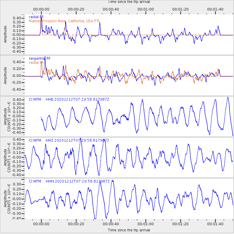
MPM Manuel Prospect Mine, California, USA - Earthquake Result Viewer
*The percent match for this event was below the threshold and hence no stack was calculated.
| Earthquake location: |
Near East Coast Of Honshu, Japan |
| Earthquake latitude/longitude: |
40.1/142.0 |
| Earthquake time(UTC): |
2020/12/12 (347) 07:18:55 GMT |
| Earthquake Depth: |
60 km |
| Earthquake Magnitude: |
5.5 Mww |
| Earthquake Catalog/Contributor: |
NEIC PDE/us |
|
| Network: |
CI Caltech Regional Seismic Network |
| Station: |
MPM Manuel Prospect Mine, California, USA |
| Lat/Lon: |
36.06 N/117.49 W |
| Elevation: |
185 m |
|
| Distance: |
74.8 deg |
| Az: |
55.636 deg |
| Baz: |
308.633 deg |
| Ray Param: |
$rayparam |
*The percent match for this event was below the threshold and hence was not used in the summary stack. |
|
| Radial Match: |
57.93158 % |
| Radial Bump: |
400 |
| Transverse Match: |
52.13461 % |
| Transverse Bump: |
400 |
| SOD ConfigId: |
23341671 |
| Insert Time: |
2020-12-26 08:25:32.496 +0000 |
| GWidth: |
2.5 |
| Max Bumps: |
400 |
| Tol: |
0.001 |
|
Signal To Noise
| Channel | StoN | STA | LTA |
| CI:MPM: :HHZ:20201212T07:29:58.817987Z | 1.0655767 | 1.6348626E-7 | 1.5342516E-7 |
| CI:MPM: :HHN:20201212T07:29:58.817987Z | 0.64058 | 8.262372E-8 | 1.2898268E-7 |
| CI:MPM: :HHE:20201212T07:29:58.817987Z | 1.6266749 | 2.5219424E-7 | 1.5503666E-7 |
| Arrivals |
| Ps | |
| PpPs | |
| PsPs/PpSs | |


