You are here: Home > Network List > IU - Global Seismograph Network (GSN - IRIS/USGS) Stations List
> Station JOHN Johnston Island, USA > Earthquake Result Viewer
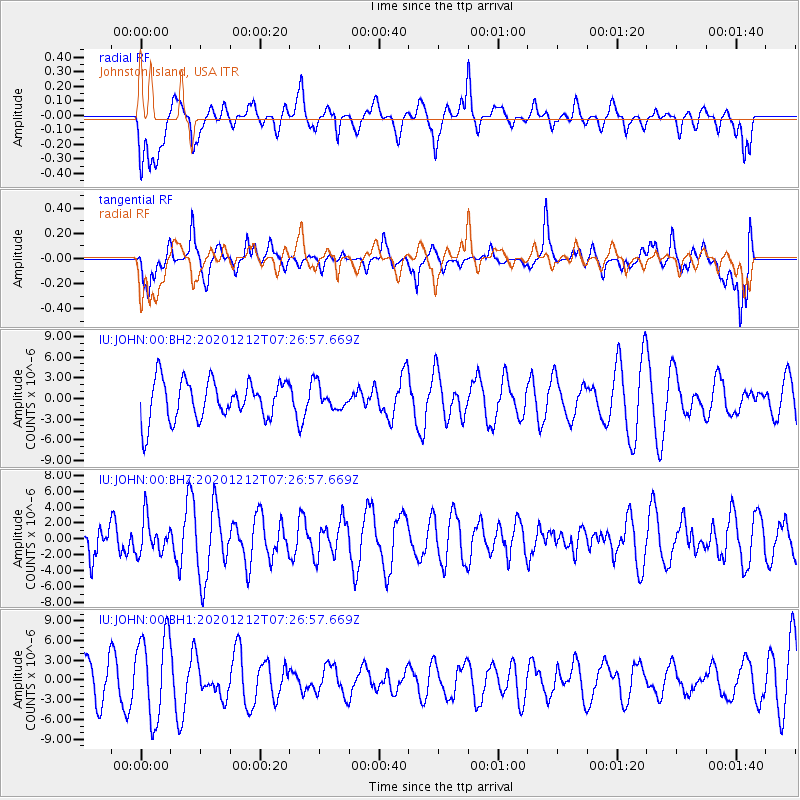
JOHN Johnston Island, USA - Earthquake Result Viewer
*The percent match for this event was below the threshold and hence no stack was calculated.
| Earthquake location: |
Near East Coast Of Honshu, Japan |
| Earthquake latitude/longitude: |
40.1/142.0 |
| Earthquake time(UTC): |
2020/12/12 (347) 07:18:55 GMT |
| Earthquake Depth: |
60 km |
| Earthquake Magnitude: |
5.5 Mww |
| Earthquake Catalog/Contributor: |
NEIC PDE/us |
|
| Network: |
IU Global Seismograph Network (GSN - IRIS/USGS) |
| Station: |
JOHN Johnston Island, USA |
| Lat/Lon: |
16.73 N/169.53 W |
| Elevation: |
2.0 m |
|
| Distance: |
47.9 deg |
| Az: |
104.673 deg |
| Baz: |
309.271 deg |
| Ray Param: |
$rayparam |
*The percent match for this event was below the threshold and hence was not used in the summary stack. |
|
| Radial Match: |
49.217613 % |
| Radial Bump: |
400 |
| Transverse Match: |
53.626793 % |
| Transverse Bump: |
400 |
| SOD ConfigId: |
23341671 |
| Insert Time: |
2020-12-26 08:29:31.561 +0000 |
| GWidth: |
2.5 |
| Max Bumps: |
400 |
| Tol: |
0.001 |
|
Signal To Noise
| Channel | StoN | STA | LTA |
| IU:JOHN:00:BHZ:20201212T07:26:57.669Z | 1.0892977 | 2.2262104E-6 | 2.0437117E-6 |
| IU:JOHN:00:BH1:20201212T07:26:57.669Z | 1.9197782 | 6.4688606E-6 | 3.3695876E-6 |
| IU:JOHN:00:BH2:20201212T07:26:57.669Z | 0.5912188 | 1.6885424E-6 | 2.8560362E-6 |
| Arrivals |
| Ps | |
| PpPs | |
| PsPs/PpSs | |


