You are here: Home > Network List > GE - GEOFON Stations List
> Station PSZ GKKI/GEOFON Station Piszkes, Hungary > Earthquake Result Viewer
PSZ GKKI/GEOFON Station Piszkes, Hungary - Earthquake Result Viewer
| Earthquake location: |
Kuril Islands |
| Earthquake latitude/longitude: |
45.4/151.6 |
| Earthquake time(UTC): |
1999/05/08 (128) 19:44:35 GMT |
| Earthquake Depth: |
63 km |
| Earthquake Magnitude: |
6.2 MB, 5.3 MS, 5.9 MW, 5.9 MW |
| Earthquake Catalog/Contributor: |
WHDF/NEIC |
|
| Network: |
GE GEOFON |
| Station: |
PSZ GKKI/GEOFON Station Piszkes, Hungary |
| Lat/Lon: |
47.92 N/19.89 E |
| Elevation: |
940 m |
|
| Distance: |
77.9 deg |
| Az: |
329.106 deg |
| Baz: |
32.501 deg |
| Ray Param: |
0.04991096 |
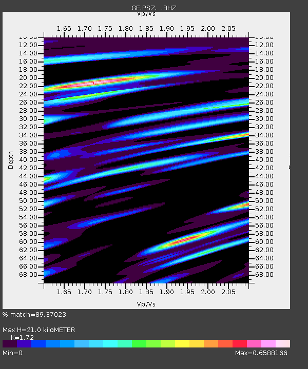
| Estimated Moho Depth: |
21.0 km |
| Estimated Crust Vp/Vs: |
1.72 |
| Assumed Crust Vp: |
6.155 km/s |
| Estimated Crust Vs: |
3.578 km/s |
| Estimated Crust Poisson's Ratio: |
0.24 |
|
| Radial Match: |
89.37023 % |
| Radial Bump: |
400 |
| Transverse Match: |
93.22411 % |
| Transverse Bump: |
400 |
| SOD ConfigId: |
4480 |
| Insert Time: |
2010-03-09 04:01:07.608 +0000 |
| GWidth: |
2.5 |
| Max Bumps: |
400 |
| Tol: |
0.001 |
|

Signal To Noise
| Channel | StoN | STA | LTA |
| GE:PSZ: :BHZ:19990508T19:55:55.752002Z | 60.346603 | 3.5557064E-6 | 5.8921398E-8 |
| GE:PSZ: :BHN:19990508T19:55:55.752002Z | 13.562395 | 8.54045E-7 | 6.297155E-8 |
| GE:PSZ: :BHE:19990508T19:55:55.752002Z | 15.8542595 | 8.378291E-7 | 5.2845678E-8 |
| Arrivals |
| Ps | 2.5 SECOND |
| PpPs | 9.0 SECOND |
| PsPs/PpSs | 12 SECOND |


