You are here: Home > Network List > TA - USArray Transportable Network (new EarthScope stations) Stations List
> Station I30M Mount Dempster, Yukon, CAN > Earthquake Result Viewer
I30M Mount Dempster, Yukon, CAN - Earthquake Result Viewer
*The percent match for this event was below the threshold and hence no stack was calculated.
| Earthquake location: |
Near East Coast Of Honshu, Japan |
| Earthquake latitude/longitude: |
40.1/142.0 |
| Earthquake time(UTC): |
2020/12/12 (347) 07:18:55 GMT |
| Earthquake Depth: |
60 km |
| Earthquake Magnitude: |
5.5 Mww |
| Earthquake Catalog/Contributor: |
NEIC PDE/us |
|
| Network: |
TA USArray Transportable Network (new EarthScope stations) |
| Station: |
I30M Mount Dempster, Yukon, CAN |
| Lat/Lon: |
65.22 N/136.38 W |
| Elevation: |
1399 m |
|
| Distance: |
51.0 deg |
| Az: |
32.433 deg |
| Baz: |
282.614 deg |
| Ray Param: |
$rayparam |
*The percent match for this event was below the threshold and hence was not used in the summary stack. |
|
| Radial Match: |
45.01655 % |
| Radial Bump: |
400 |
| Transverse Match: |
45.37732 % |
| Transverse Bump: |
400 |
| SOD ConfigId: |
23341671 |
| Insert Time: |
2020-12-26 08:36:18.120 +0000 |
| GWidth: |
2.5 |
| Max Bumps: |
400 |
| Tol: |
0.001 |
|
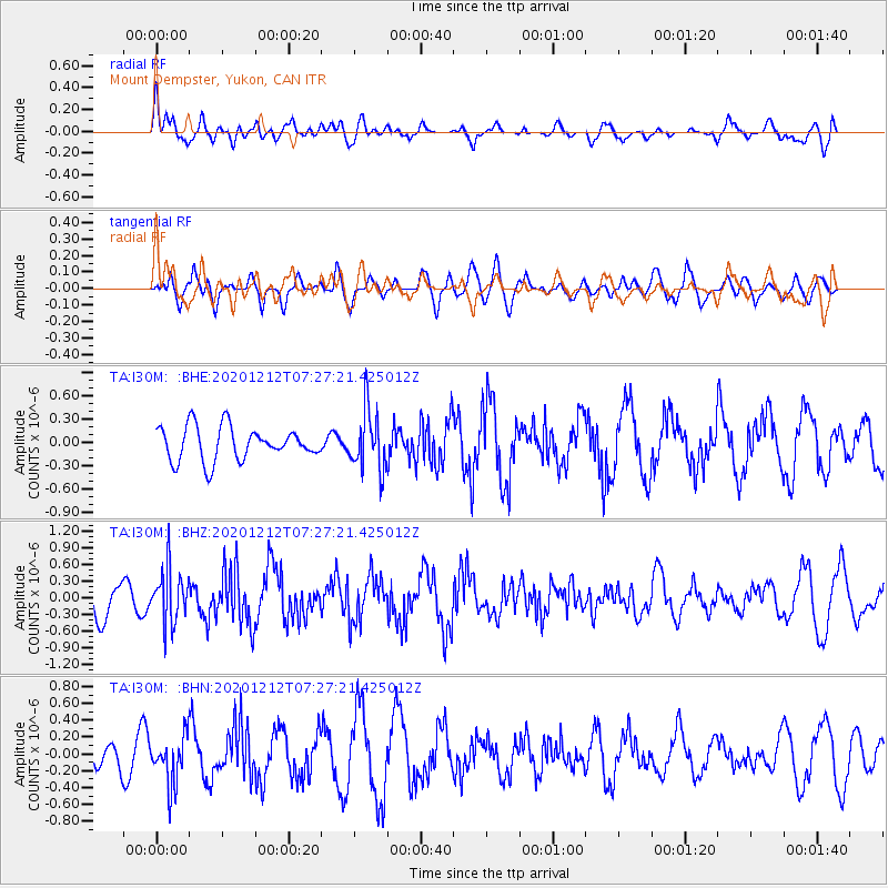
Signal To Noise
| Channel | StoN | STA | LTA |
| TA:I30M: :BHZ:20201212T07:27:21.425012Z | 1.9340703 | 4.7374414E-7 | 2.449467E-7 |
| TA:I30M: :BHN:20201212T07:27:21.425012Z | 1.1766121 | 2.919789E-7 | 2.481522E-7 |
| TA:I30M: :BHE:20201212T07:27:21.425012Z | 1.7666497 | 3.7984384E-7 | 2.1500801E-7 |
| Arrivals |
| Ps | |
| PpPs | |
| PsPs/PpSs | |


