You are here: Home > Network List > GE - GEOFON Stations List
> Station PSZ GKKI/GEOFON Station Piszkes, Hungary > Earthquake Result Viewer
PSZ GKKI/GEOFON Station Piszkes, Hungary - Earthquake Result Viewer
| Earthquake location: |
Hindu Kush Region, Afghanistan |
| Earthquake latitude/longitude: |
36.4/70.7 |
| Earthquake time(UTC): |
1999/06/21 (172) 17:37:27 GMT |
| Earthquake Depth: |
230 km |
| Earthquake Magnitude: |
5.6 MW, 5.4 MB, 5.5 MW |
| Earthquake Catalog/Contributor: |
WHDF/NEIC |
|
| Network: |
GE GEOFON |
| Station: |
PSZ GKKI/GEOFON Station Piszkes, Hungary |
| Lat/Lon: |
47.92 N/19.89 E |
| Elevation: |
940 m |
|
| Distance: |
38.7 deg |
| Az: |
303.571 deg |
| Baz: |
88.163 deg |
| Ray Param: |
0.074492484 |
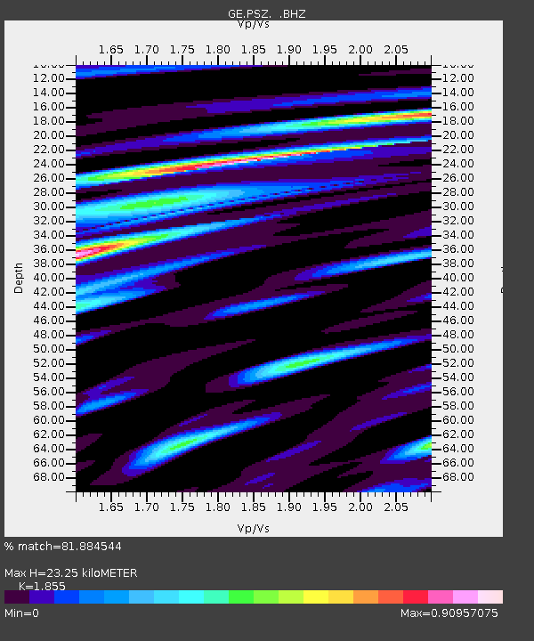
| Estimated Moho Depth: |
23.25 km |
| Estimated Crust Vp/Vs: |
1.86 |
| Assumed Crust Vp: |
6.155 km/s |
| Estimated Crust Vs: |
3.318 km/s |
| Estimated Crust Poisson's Ratio: |
0.30 |
|
| Radial Match: |
81.884544 % |
| Radial Bump: |
245 |
| Transverse Match: |
55.498055 % |
| Transverse Bump: |
400 |
| SOD ConfigId: |
4480 |
| Insert Time: |
2010-03-09 04:01:55.139 +0000 |
| GWidth: |
2.5 |
| Max Bumps: |
400 |
| Tol: |
0.001 |
|

Signal To Noise
| Channel | StoN | STA | LTA |
| GE:PSZ: :BHZ:19990621T17:43:58.603004Z | 8.988247 | 5.2404835E-7 | 5.8303733E-8 |
| GE:PSZ: :BHN:19990621T17:43:58.603004Z | 3.3925738 | 1.3263177E-7 | 3.9094733E-8 |
| GE:PSZ: :BHE:19990621T17:43:58.603004Z | 4.1863494 | 2.2237785E-7 | 5.3119756E-8 |
| Arrivals |
| Ps | 3.4 SECOND |
| PpPs | 10 SECOND |
| PsPs/PpSs | 14 SECOND |


