You are here: Home > Network List > GE - GEOFON Stations List
> Station PSZ GKKI/GEOFON Station Piszkes, Hungary > Earthquake Result Viewer
PSZ GKKI/GEOFON Station Piszkes, Hungary - Earthquake Result Viewer
| Earthquake location: |
Qinghai, China |
| Earthquake latitude/longitude: |
37.5/96.5 |
| Earthquake time(UTC): |
2003/04/17 (107) 00:48:38 GMT |
| Earthquake Depth: |
14 km |
| Earthquake Magnitude: |
6.2 MB, 6.3 MS, 6.4 MW, 6.2 MW |
| Earthquake Catalog/Contributor: |
WHDF/NEIC |
|
| Network: |
GE GEOFON |
| Station: |
PSZ GKKI/GEOFON Station Piszkes, Hungary |
| Lat/Lon: |
47.92 N/19.89 E |
| Elevation: |
940 m |
|
| Distance: |
55.0 deg |
| Az: |
307.03 deg |
| Baz: |
70.653 deg |
| Ray Param: |
0.065044686 |
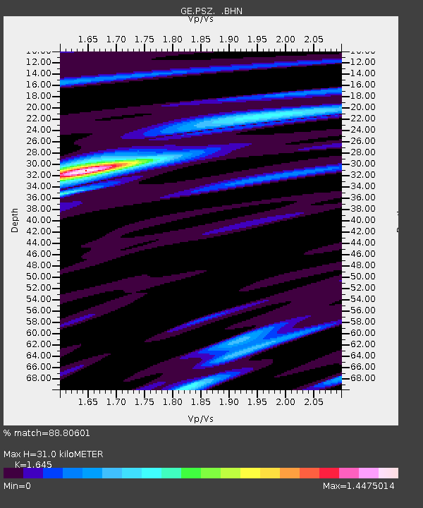
| Estimated Moho Depth: |
31.0 km |
| Estimated Crust Vp/Vs: |
1.64 |
| Assumed Crust Vp: |
6.155 km/s |
| Estimated Crust Vs: |
3.741 km/s |
| Estimated Crust Poisson's Ratio: |
0.21 |
|
| Radial Match: |
88.80601 % |
| Radial Bump: |
358 |
| Transverse Match: |
79.767944 % |
| Transverse Bump: |
400 |
| SOD ConfigId: |
4714 |
| Insert Time: |
2010-03-09 04:02:03.609 +0000 |
| GWidth: |
2.5 |
| Max Bumps: |
400 |
| Tol: |
0.001 |
|

Signal To Noise
| Channel | StoN | STA | LTA |
| GE:PSZ: :BHN:20030417T00:57:38.645002Z | 1.8971847 | 1.1846997E-7 | 6.244514E-8 |
| GE:PSZ: :BHE:20030417T00:57:38.645002Z | 4.246438 | 3.1540912E-7 | 7.427616E-8 |
| GE:PSZ: :BHZ:20030417T00:57:38.645002Z | 10.5821 | 7.1127516E-7 | 6.7214934E-8 |
| Arrivals |
| Ps | 3.4 SECOND |
| PpPs | 13 SECOND |
| PsPs/PpSs | 16 SECOND |


