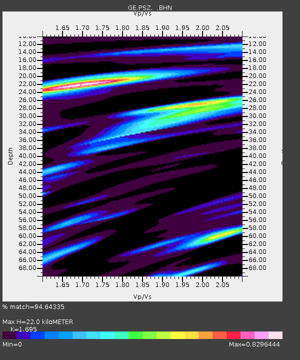
PSZ GKKI/GEOFON Station Piszkes, Hungary - Earthquake Result Viewer

Earthquake location: Rat Islands, Aleutian Islands
Earthquake latitude/longitude: 51.3/178.0
Earthquake time(UTC): 2003/03/17 (076) 16:36:17 GMT
Earthquake Depth: 33 km
Earthquake Magnitude: 5.9 MB, 6.7 MS, 7.0 MW, 7.0 MW
Earthquake Catalog/Contributor: WHDF/NEIC
Network: GE GEOFON
Station: PSZ GKKI/GEOFON Station Piszkes, Hungary
Lat/Lon: 47.92 N/19.89 E
Elevation: 940 m
Distance: 79.4 deg
Az: 345.201 deg
Baz: 13.8 deg
Ray Param: 0.048931878
Estimated Moho Depth: 22.0 km
Estimated Crust Vp/Vs: 1.70
Assumed Crust Vp: 6.155 km/s
Estimated Crust Vs: 3.631 km/s
Estimated Crust Poisson's Ratio: 0.23
Radial Match: 94.64335 %
Radial Bump: 400
Transverse Match: 81.456 %
Transverse Bump: 400
SOD ConfigId: 4714
Insert Time: 2010-03-09 04:02:05.126 +0000
GWidth: 2.5
Max Bumps: 400
Tol: 0.001

Signal To Noise

ChannelStoNSTALTA
GE:PSZ: :BHN:20030317T16:47:49.093997Z3.13153316.0934525E-71.9458368E-7
GE:PSZ: :BHE:20030317T16:47:49.093997Z2.94402865.922283E-72.0116254E-7
GE:PSZ: :BHZ:20030317T16:47:49.093997Z14.8797272.4256792E-61.6301907E-7
Arrivals
Ps2.6 SECOND
PpPs9.4 SECOND
PsPs/PpSs12 SECOND