You are here: Home > Network List > CI - Caltech Regional Seismic Network Stations List
> Station LRL Laurel Mtn Radio Fac, Ridgecrest, CA, USA > Earthquake Result Viewer
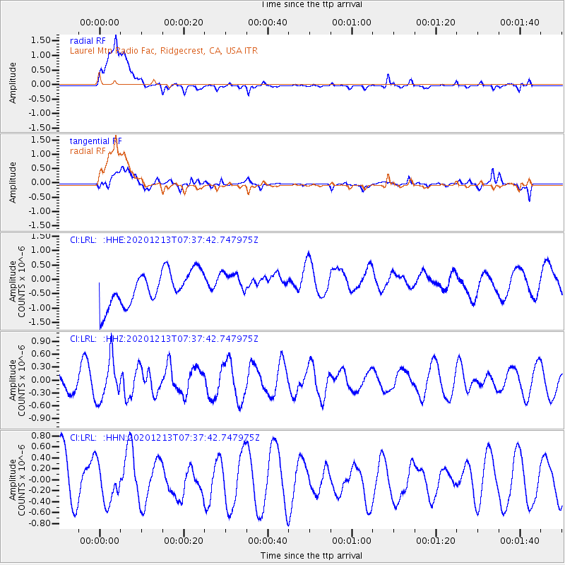
LRL Laurel Mtn Radio Fac, Ridgecrest, CA, USA - Earthquake Result Viewer
*The percent match for this event was below the threshold and hence no stack was calculated.
| Earthquake location: |
South Of Fiji Islands |
| Earthquake latitude/longitude: |
-24.0/176.6 |
| Earthquake time(UTC): |
2020/12/13 (348) 07:25:34 GMT |
| Earthquake Depth: |
10 km |
| Earthquake Magnitude: |
5.3 Mww |
| Earthquake Catalog/Contributor: |
NEIC PDE/us |
|
| Network: |
CI Caltech Regional Seismic Network |
| Station: |
LRL Laurel Mtn Radio Fac, Ridgecrest, CA, USA |
| Lat/Lon: |
35.48 N/117.68 W |
| Elevation: |
1340 m |
|
| Distance: |
85.8 deg |
| Az: |
48.259 deg |
| Baz: |
236.715 deg |
| Ray Param: |
$rayparam |
*The percent match for this event was below the threshold and hence was not used in the summary stack. |
|
| Radial Match: |
65.78791 % |
| Radial Bump: |
400 |
| Transverse Match: |
63.422695 % |
| Transverse Bump: |
400 |
| SOD ConfigId: |
23341671 |
| Insert Time: |
2020-12-27 08:31:49.622 +0000 |
| GWidth: |
2.5 |
| Max Bumps: |
400 |
| Tol: |
0.001 |
|
Signal To Noise
| Channel | StoN | STA | LTA |
| CI:LRL: :HHZ:20201213T07:37:42.747975Z | 2.555679 | 4.7990983E-7 | 1.8778172E-7 |
| CI:LRL: :HHN:20201213T07:37:42.747975Z | 0.7957479 | 3.484643E-7 | 4.3790791E-7 |
| CI:LRL: :HHE:20201213T07:37:42.747975Z | 0.72714746 | 4.241569E-7 | 5.833162E-7 |
| Arrivals |
| Ps | |
| PpPs | |
| PsPs/PpSs | |


