You are here: Home > Network List > XC91 - Tibetan Plateau Broadband Experiment Stations List
> Station USHU XC.USHU > Earthquake Result Viewer
USHU XC.USHU - Earthquake Result Viewer
| Earthquake location: |
Irian Jaya Region, Indonesia |
| Earthquake latitude/longitude: |
-4.5/135.4 |
| Earthquake time(UTC): |
1991/10/17 (290) 05:20:57 GMT |
| Earthquake Depth: |
22 km |
| Earthquake Magnitude: |
5.6 MB, 5.8 MS |
| Earthquake Catalog/Contributor: |
WHDF/NEIC |
|
| Network: |
XC Tibetan Plateau Broadband Experiment |
| Station: |
USHU XC.USHU |
| Lat/Lon: |
33.01 N/97.01 E |
| Elevation: |
3727 m |
|
| Distance: |
52.1 deg |
| Az: |
318.609 deg |
| Baz: |
128.326 deg |
| Ray Param: |
0.06692044 |
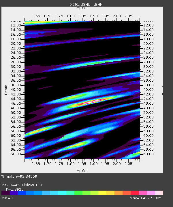
| Estimated Moho Depth: |
45.0 km |
| Estimated Crust Vp/Vs: |
1.89 |
| Assumed Crust Vp: |
6.514 km/s |
| Estimated Crust Vs: |
3.442 km/s |
| Estimated Crust Poisson's Ratio: |
0.31 |
|
| Radial Match: |
92.34509 % |
| Radial Bump: |
400 |
| Transverse Match: |
80.828316 % |
| Transverse Bump: |
400 |
| SOD ConfigId: |
23496 |
| Insert Time: |
2010-02-26 15:12:54.929 +0000 |
| GWidth: |
2.5 |
| Max Bumps: |
400 |
| Tol: |
0.001 |
|
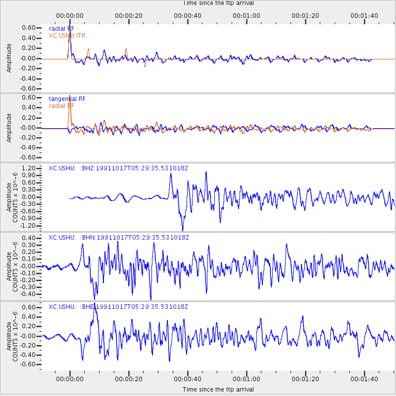
Signal To Noise
| Channel | StoN | STA | LTA |
| XC:USHU: :BHN:19911017T05:29:35.531018Z | 5.130028 | 1.1362392E-7 | 2.2148791E-8 |
| XC:USHU: :BHE:19911017T05:29:35.531018Z | 7.8291802 | 1.5787646E-7 | 2.0165132E-8 |
| XC:USHU: :BHZ:19911017T05:29:35.531018Z | 4.7118173 | 3.327694E-7 | 7.0624424E-8 |
| Arrivals |
| Ps | 6.5 SECOND |
| PpPs | 19 SECOND |
| PsPs/PpSs | 25 SECOND |


