You are here: Home > Network List > TA - USArray Transportable Network (new EarthScope stations) Stations List
> Station D23K Nanushuk River, AK USA > Earthquake Result Viewer
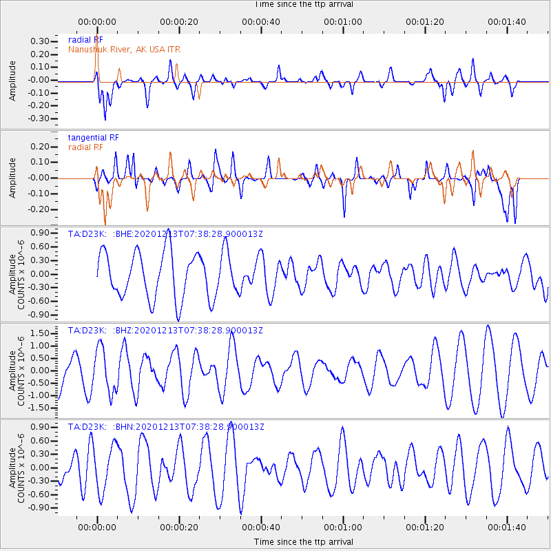
D23K Nanushuk River, AK USA - Earthquake Result Viewer
*The percent match for this event was below the threshold and hence no stack was calculated.
| Earthquake location: |
South Of Fiji Islands |
| Earthquake latitude/longitude: |
-24.0/176.6 |
| Earthquake time(UTC): |
2020/12/13 (348) 07:25:34 GMT |
| Earthquake Depth: |
10 km |
| Earthquake Magnitude: |
5.3 Mww |
| Earthquake Catalog/Contributor: |
NEIC PDE/us |
|
| Network: |
TA USArray Transportable Network (new EarthScope stations) |
| Station: |
D23K Nanushuk River, AK USA |
| Lat/Lon: |
68.97 N/150.68 W |
| Elevation: |
406 m |
|
| Distance: |
95.7 deg |
| Az: |
11.324 deg |
| Baz: |
209.822 deg |
| Ray Param: |
$rayparam |
*The percent match for this event was below the threshold and hence was not used in the summary stack. |
|
| Radial Match: |
55.838528 % |
| Radial Bump: |
400 |
| Transverse Match: |
56.54497 % |
| Transverse Bump: |
400 |
| SOD ConfigId: |
23341671 |
| Insert Time: |
2020-12-27 08:36:28.852 +0000 |
| GWidth: |
2.5 |
| Max Bumps: |
400 |
| Tol: |
0.001 |
|
Signal To Noise
| Channel | StoN | STA | LTA |
| TA:D23K: :BHZ:20201213T07:38:28.900013Z | 1.2426286 | 9.03613E-7 | 7.271787E-7 |
| TA:D23K: :BHN:20201213T07:38:28.900013Z | 2.3323472 | 5.081088E-7 | 2.17853E-7 |
| TA:D23K: :BHE:20201213T07:38:28.900013Z | 0.8877098 | 4.5211044E-7 | 5.092998E-7 |
| Arrivals |
| Ps | |
| PpPs | |
| PsPs/PpSs | |


