You are here: Home > Network List > TA - USArray Transportable Network (new EarthScope stations) Stations List
> Station F26K Sheenjek River, AK, USA > Earthquake Result Viewer
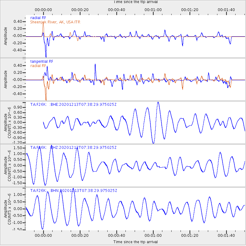
F26K Sheenjek River, AK, USA - Earthquake Result Viewer
*The percent match for this event was below the threshold and hence no stack was calculated.
| Earthquake location: |
South Of Fiji Islands |
| Earthquake latitude/longitude: |
-24.0/176.6 |
| Earthquake time(UTC): |
2020/12/13 (348) 07:25:34 GMT |
| Earthquake Depth: |
10 km |
| Earthquake Magnitude: |
5.3 Mww |
| Earthquake Catalog/Contributor: |
NEIC PDE/us |
|
| Network: |
TA USArray Transportable Network (new EarthScope stations) |
| Station: |
F26K Sheenjek River, AK, USA |
| Lat/Lon: |
67.69 N/144.15 W |
| Elevation: |
683 m |
|
| Distance: |
96.0 deg |
| Az: |
14.069 deg |
| Baz: |
215.611 deg |
| Ray Param: |
$rayparam |
*The percent match for this event was below the threshold and hence was not used in the summary stack. |
|
| Radial Match: |
70.66863 % |
| Radial Bump: |
400 |
| Transverse Match: |
84.41048 % |
| Transverse Bump: |
347 |
| SOD ConfigId: |
23341671 |
| Insert Time: |
2020-12-27 08:36:37.083 +0000 |
| GWidth: |
2.5 |
| Max Bumps: |
400 |
| Tol: |
0.001 |
|
Signal To Noise
| Channel | StoN | STA | LTA |
| TA:F26K: :BHZ:20201213T07:38:29.975025Z | 1.8878807 | 1.1812128E-6 | 6.2568193E-7 |
| TA:F26K: :BHN:20201213T07:38:29.975025Z | 2.0230615 | 9.2304435E-7 | 4.5626118E-7 |
| TA:F26K: :BHE:20201213T07:38:29.975025Z | 0.8244942 | 1.6768102E-7 | 2.0337441E-7 |
| Arrivals |
| Ps | |
| PpPs | |
| PsPs/PpSs | |


