You are here: Home > Network List > GE - GEOFON Stations List
> Station PSZ GKKI/GEOFON Station Piszkes, Hungary > Earthquake Result Viewer
PSZ GKKI/GEOFON Station Piszkes, Hungary - Earthquake Result Viewer
| Earthquake location: |
Ryukyu Islands, Japan |
| Earthquake latitude/longitude: |
26.5/128.9 |
| Earthquake time(UTC): |
2004/07/22 (204) 09:45:14 GMT |
| Earthquake Depth: |
21 km |
| Earthquake Magnitude: |
6.1 MB, 5.7 MS, 6.1 MW, 6.1 MW |
| Earthquake Catalog/Contributor: |
WHDF/NEIC |
|
| Network: |
GE GEOFON |
| Station: |
PSZ GKKI/GEOFON Station Piszkes, Hungary |
| Lat/Lon: |
47.92 N/19.89 E |
| Elevation: |
940 m |
|
| Distance: |
82.4 deg |
| Az: |
320.086 deg |
| Baz: |
58.745 deg |
| Ray Param: |
0.046883732 |
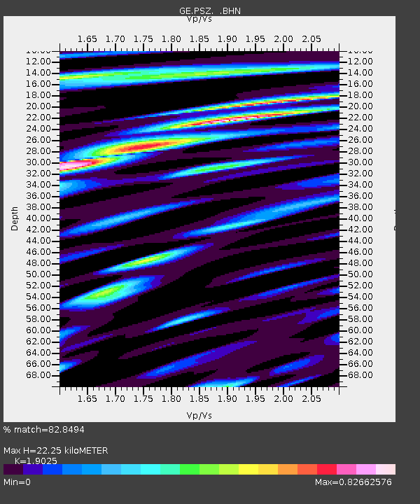
| Estimated Moho Depth: |
22.25 km |
| Estimated Crust Vp/Vs: |
1.90 |
| Assumed Crust Vp: |
6.155 km/s |
| Estimated Crust Vs: |
3.235 km/s |
| Estimated Crust Poisson's Ratio: |
0.31 |
|
| Radial Match: |
82.8494 % |
| Radial Bump: |
400 |
| Transverse Match: |
76.21135 % |
| Transverse Bump: |
400 |
| SOD ConfigId: |
2459 |
| Insert Time: |
2010-03-09 04:02:40.362 +0000 |
| GWidth: |
2.5 |
| Max Bumps: |
400 |
| Tol: |
0.001 |
|

Signal To Noise
| Channel | StoN | STA | LTA |
| GE:PSZ: :BHN:20040722T09:57:04.04502Z | 1.6917673 | 9.468208E-8 | 5.596637E-8 |
| GE:PSZ: :BHE:20040722T09:57:04.04502Z | 3.8845127 | 1.2091516E-7 | 3.11275E-8 |
| GE:PSZ: :BHZ:20040722T09:57:04.04502Z | 7.1006002 | 3.863157E-7 | 5.4406062E-8 |
| Arrivals |
| Ps | 3.3 SECOND |
| PpPs | 10 SECOND |
| PsPs/PpSs | 14 SECOND |


