You are here: Home > Network List > GE - GEOFON Stations List
> Station PSZ GKKI/GEOFON Station Piszkes, Hungary > Earthquake Result Viewer
PSZ GKKI/GEOFON Station Piszkes, Hungary - Earthquake Result Viewer
| Earthquake location: |
Southeast Of Taiwan |
| Earthquake latitude/longitude: |
22.3/125.3 |
| Earthquake time(UTC): |
1998/05/03 (123) 23:30:21 GMT |
| Earthquake Depth: |
33 km |
| Earthquake Magnitude: |
6.4 MB, 7.3 MS, 7.5 UNKNOWN, 7.5 ME |
| Earthquake Catalog/Contributor: |
WHDF/NEIC |
|
| Network: |
GE GEOFON |
| Station: |
PSZ GKKI/GEOFON Station Piszkes, Hungary |
| Lat/Lon: |
47.92 N/19.89 E |
| Elevation: |
940 m |
|
| Distance: |
83.5 deg |
| Az: |
319.254 deg |
| Baz: |
63.972 deg |
| Ray Param: |
0.046119183 |
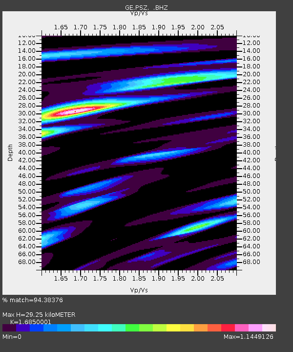
| Estimated Moho Depth: |
29.25 km |
| Estimated Crust Vp/Vs: |
1.69 |
| Assumed Crust Vp: |
6.155 km/s |
| Estimated Crust Vs: |
3.653 km/s |
| Estimated Crust Poisson's Ratio: |
0.23 |
|
| Radial Match: |
94.38376 % |
| Radial Bump: |
400 |
| Transverse Match: |
91.36863 % |
| Transverse Bump: |
400 |
| SOD ConfigId: |
4480 |
| Insert Time: |
2010-03-09 04:02:59.444 +0000 |
| GWidth: |
2.5 |
| Max Bumps: |
400 |
| Tol: |
0.001 |
|

Signal To Noise
| Channel | StoN | STA | LTA |
| GE:PSZ: :BHZ:19980503T23:42:15.064001Z | 6.423018 | 3.4239702E-7 | 5.330781E-8 |
| GE:PSZ: :BHN:19980503T23:42:15.064001Z | 1.652727 | 9.9764335E-8 | 6.036347E-8 |
| GE:PSZ: :BHE:19980503T23:42:15.064001Z | 3.1554837 | 1.4976133E-7 | 4.746066E-8 |
| Arrivals |
| Ps | 3.3 SECOND |
| PpPs | 12 SECOND |
| PsPs/PpSs | 16 SECOND |


