You are here: Home > Network List > GE - GEOFON Stations List
> Station PSZ GKKI/GEOFON Station Piszkes, Hungary > Earthquake Result Viewer
PSZ GKKI/GEOFON Station Piszkes, Hungary - Earthquake Result Viewer
| Earthquake location: |
Afghanistan-Tajikistan Bord Reg. |
| Earthquake latitude/longitude: |
36.6/71.3 |
| Earthquake time(UTC): |
2005/07/01 (182) 03:48:28 GMT |
| Earthquake Depth: |
63 km |
| Earthquake Magnitude: |
5.4 MB, 5.6 MW, 5.5 MW |
| Earthquake Catalog/Contributor: |
WHDF/NEIC |
|
| Network: |
GE GEOFON |
| Station: |
PSZ GKKI/GEOFON Station Piszkes, Hungary |
| Lat/Lon: |
47.92 N/19.89 E |
| Elevation: |
940 m |
|
| Distance: |
39.0 deg |
| Az: |
303.41 deg |
| Baz: |
87.489 deg |
| Ray Param: |
0.07502681 |
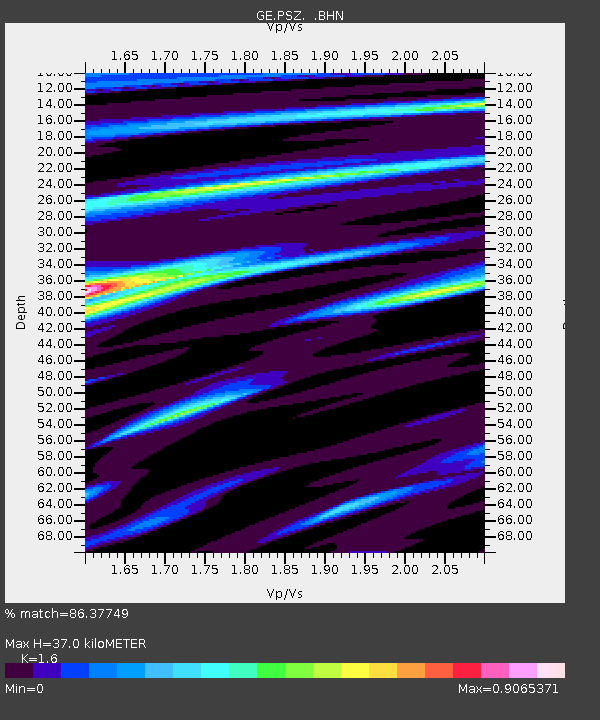
| Estimated Moho Depth: |
37.0 km |
| Estimated Crust Vp/Vs: |
1.60 |
| Assumed Crust Vp: |
6.155 km/s |
| Estimated Crust Vs: |
3.847 km/s |
| Estimated Crust Poisson's Ratio: |
0.18 |
|
| Radial Match: |
86.37749 % |
| Radial Bump: |
400 |
| Transverse Match: |
56.86606 % |
| Transverse Bump: |
400 |
| SOD ConfigId: |
2669 |
| Insert Time: |
2010-03-09 04:03:02.337 +0000 |
| GWidth: |
2.5 |
| Max Bumps: |
400 |
| Tol: |
0.001 |
|

Signal To Noise
| Channel | StoN | STA | LTA |
| GE:PSZ: :BHN:20050701T03:55:18.993986Z | 1.9038184 | 5.2822504E-8 | 2.7745559E-8 |
| GE:PSZ: :BHE:20050701T03:55:18.993986Z | 2.011984 | 7.743608E-8 | 3.848742E-8 |
| GE:PSZ: :BHZ:20050701T03:55:18.993986Z | 3.2236104 | 1.2127899E-7 | 3.7622097E-8 |
| Arrivals |
| Ps | 3.9 SECOND |
| PpPs | 15 SECOND |
| PsPs/PpSs | 18 SECOND |


