You are here: Home > Network List > US - United States National Seismic Network Stations List
> Station MIAR Mount Ida, Arkansas, USA > Earthquake Result Viewer
MIAR Mount Ida, Arkansas, USA - Earthquake Result Viewer
*The percent match for this event was below the threshold and hence no stack was calculated.
| Earthquake location: |
Andreanof Islands, Aleutian Is. |
| Earthquake latitude/longitude: |
51.4/-174.0 |
| Earthquake time(UTC): |
2016/03/12 (072) 13:23:38 GMT |
| Earthquake Depth: |
13 km |
| Earthquake Magnitude: |
5.6 mww |
| Earthquake Catalog/Contributor: |
NEIC PDE/ |
|
| Network: |
US United States National Seismic Network |
| Station: |
MIAR Mount Ida, Arkansas, USA |
| Lat/Lon: |
34.55 N/93.58 W |
| Elevation: |
207 m |
|
| Distance: |
58.2 deg |
| Az: |
73.195 deg |
| Baz: |
313.472 deg |
| Ray Param: |
$rayparam |
*The percent match for this event was below the threshold and hence was not used in the summary stack. |
|
| Radial Match: |
67.179405 % |
| Radial Bump: |
400 |
| Transverse Match: |
54.594963 % |
| Transverse Bump: |
400 |
| SOD ConfigId: |
2361031 |
| Insert Time: |
2017-10-09 15:10:55.718 +0000 |
| GWidth: |
2.5 |
| Max Bumps: |
400 |
| Tol: |
0.001 |
|
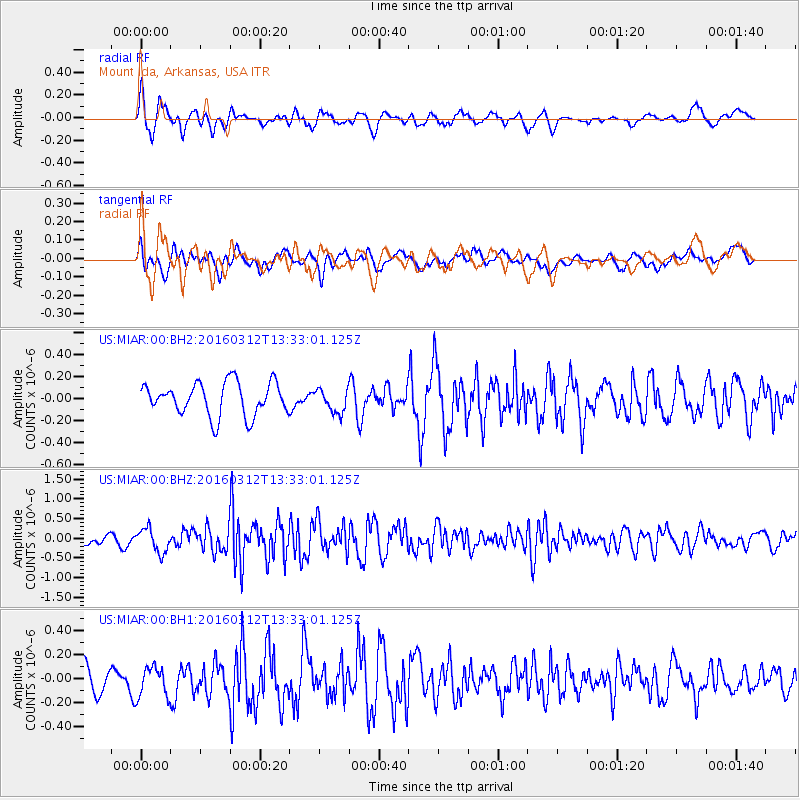
Signal To Noise
| Channel | StoN | STA | LTA |
| US:MIAR:00:BHZ:20160312T13:33:01.125Z | 1.9129236 | 3.016998E-7 | 1.577166E-7 |
| US:MIAR:00:BH1:20160312T13:33:01.125Z | 1.1643628 | 1.2852755E-7 | 1.1038444E-7 |
| US:MIAR:00:BH2:20160312T13:33:01.125Z | 0.71498084 | 1.0636763E-7 | 1.487699E-7 |
| Arrivals |
| Ps | |
| PpPs | |
| PsPs/PpSs | |


