You are here: Home > Network List > US - United States National Seismic Network Stations List
> Station EGMT Eagleton, Montana, USA > Earthquake Result Viewer
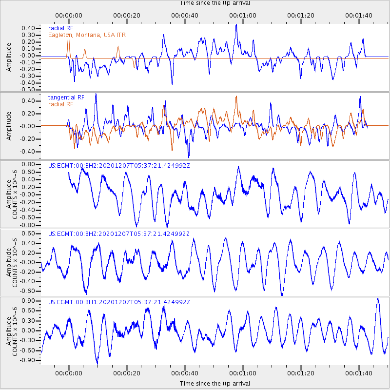
EGMT Eagleton, Montana, USA - Earthquake Result Viewer
*The percent match for this event was below the threshold and hence no stack was calculated.
| Earthquake location: |
Fiji Islands Region |
| Earthquake latitude/longitude: |
-21.0/-179.2 |
| Earthquake time(UTC): |
2020/12/07 (342) 05:25:44 GMT |
| Earthquake Depth: |
598 km |
| Earthquake Magnitude: |
5.6 Mwb |
| Earthquake Catalog/Contributor: |
NEIC PDE/us |
|
| Network: |
US United States National Seismic Network |
| Station: |
EGMT Eagleton, Montana, USA |
| Lat/Lon: |
48.02 N/109.75 W |
| Elevation: |
1055 m |
|
| Distance: |
92.5 deg |
| Az: |
38.975 deg |
| Baz: |
241.079 deg |
| Ray Param: |
$rayparam |
*The percent match for this event was below the threshold and hence was not used in the summary stack. |
|
| Radial Match: |
43.212868 % |
| Radial Bump: |
400 |
| Transverse Match: |
53.705154 % |
| Transverse Bump: |
400 |
| SOD ConfigId: |
23341671 |
| Insert Time: |
2020-12-27 14:40:27.007 +0000 |
| GWidth: |
2.5 |
| Max Bumps: |
400 |
| Tol: |
0.001 |
|
Signal To Noise
| Channel | StoN | STA | LTA |
| US:EGMT:00:BHZ:20201207T05:37:21.424992Z | 1.4848691 | 2.421553E-7 | 1.630819E-7 |
| US:EGMT:00:BH1:20201207T05:37:21.424992Z | 0.9359033 | 3.5276489E-7 | 3.7692448E-7 |
| US:EGMT:00:BH2:20201207T05:37:21.424992Z | 1.5035298 | 5.6851303E-7 | 3.781189E-7 |
| Arrivals |
| Ps | |
| PpPs | |
| PsPs/PpSs | |


