You are here: Home > Network List > XC91 - Tibetan Plateau Broadband Experiment Stations List
> Station USHU XC.USHU > Earthquake Result Viewer
USHU XC.USHU - Earthquake Result Viewer
| Earthquake location: |
Near East Coast Of Honshu, Japan |
| Earthquake latitude/longitude: |
35.7/141.1 |
| Earthquake time(UTC): |
1991/08/06 (218) 14:49:31 GMT |
| Earthquake Depth: |
34 km |
| Earthquake Magnitude: |
5.8 MB, 5.6 MS |
| Earthquake Catalog/Contributor: |
WHDF/NEIC |
|
| Network: |
XC Tibetan Plateau Broadband Experiment |
| Station: |
USHU XC.USHU |
| Lat/Lon: |
33.01 N/97.01 E |
| Elevation: |
3727 m |
|
| Distance: |
36.2 deg |
| Az: |
278.764 deg |
| Baz: |
73.13 deg |
| Ray Param: |
0.07672015 |
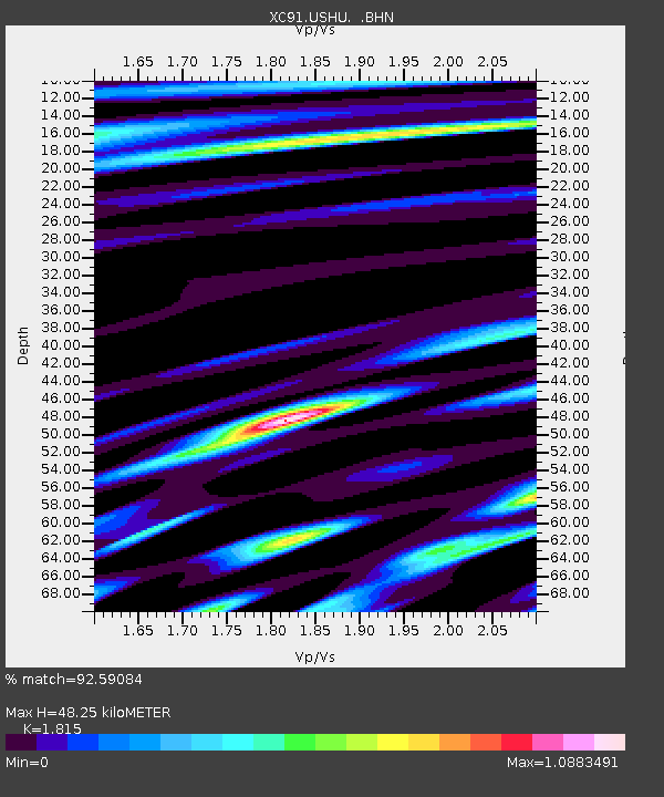
| Estimated Moho Depth: |
48.25 km |
| Estimated Crust Vp/Vs: |
1.82 |
| Assumed Crust Vp: |
6.514 km/s |
| Estimated Crust Vs: |
3.589 km/s |
| Estimated Crust Poisson's Ratio: |
0.28 |
|
| Radial Match: |
92.59084 % |
| Radial Bump: |
400 |
| Transverse Match: |
77.719666 % |
| Transverse Bump: |
400 |
| SOD ConfigId: |
23496 |
| Insert Time: |
2010-02-26 15:12:56.211 +0000 |
| GWidth: |
2.5 |
| Max Bumps: |
400 |
| Tol: |
0.001 |
|

Signal To Noise
| Channel | StoN | STA | LTA |
| XC:USHU: :BHN:19910806T14:56:00.806012Z | 12.005337 | 1.9557355E-7 | 1.6290551E-8 |
| XC:USHU: :BHE:19910806T14:56:00.806012Z | 31.937769 | 6.37831E-7 | 1.9971058E-8 |
| XC:USHU: :BHZ:19910806T14:56:00.806012Z | 29.343687 | 1.0139463E-6 | 3.4554155E-8 |
| Arrivals |
| Ps | 6.5 SECOND |
| PpPs | 19 SECOND |
| PsPs/PpSs | 26 SECOND |


