You are here: Home > Network List > IU - Global Seismograph Network (GSN - IRIS/USGS) Stations List
> Station PMG Port Moresby, New Guinea > Earthquake Result Viewer
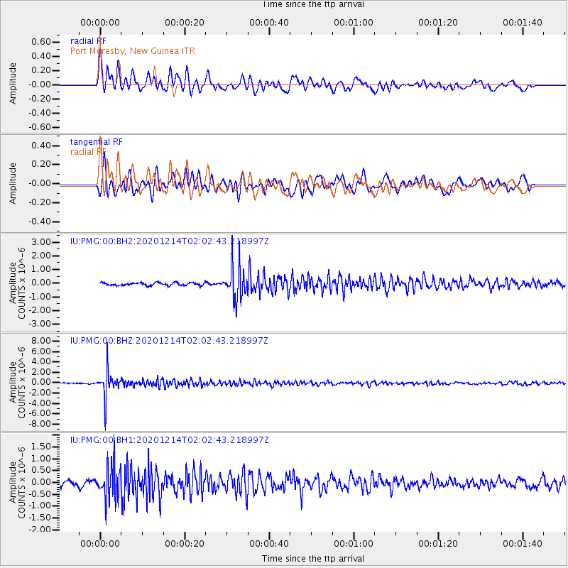
PMG Port Moresby, New Guinea - Earthquake Result Viewer
*The percent match for this event was below the threshold and hence no stack was calculated.
| Earthquake location: |
South Of Fiji Islands |
| Earthquake latitude/longitude: |
-23.9/179.9 |
| Earthquake time(UTC): |
2020/12/14 (349) 01:57:10 GMT |
| Earthquake Depth: |
530 km |
| Earthquake Magnitude: |
5.6 mww |
| Earthquake Catalog/Contributor: |
NEIC PDE/us |
|
| Network: |
IU Global Seismograph Network (GSN - IRIS/USGS) |
| Station: |
PMG Port Moresby, New Guinea |
| Lat/Lon: |
9.40 S/147.16 E |
| Elevation: |
90 m |
|
| Distance: |
34.4 deg |
| Az: |
289.244 deg |
| Baz: |
118.882 deg |
| Ray Param: |
$rayparam |
*The percent match for this event was below the threshold and hence was not used in the summary stack. |
|
| Radial Match: |
79.01447 % |
| Radial Bump: |
400 |
| Transverse Match: |
69.521225 % |
| Transverse Bump: |
400 |
| SOD ConfigId: |
23341671 |
| Insert Time: |
2020-12-28 03:07:03.902 +0000 |
| GWidth: |
2.5 |
| Max Bumps: |
400 |
| Tol: |
0.001 |
|
Signal To Noise
| Channel | StoN | STA | LTA |
| IU:PMG:00:BHZ:20201214T02:02:43.218997Z | 20.740656 | 2.4331382E-6 | 1.173125E-7 |
| IU:PMG:00:BH1:20201214T02:02:43.218997Z | 6.5533595 | 6.990876E-7 | 1.0667621E-7 |
| IU:PMG:00:BH2:20201214T02:02:43.218997Z | 12.328856 | 1.231252E-6 | 9.986749E-8 |
| Arrivals |
| Ps | |
| PpPs | |
| PsPs/PpSs | |


