You are here: Home > Network List > TA - USArray Transportable Network (new EarthScope stations) Stations List
> Station E20K Nigu River, AK, USA > Earthquake Result Viewer
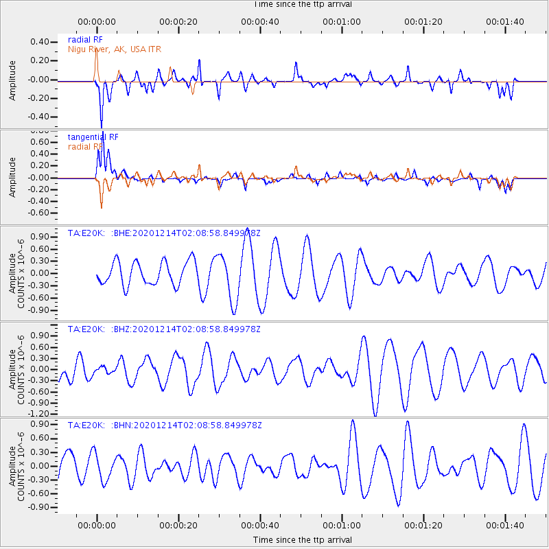
E20K Nigu River, AK, USA - Earthquake Result Viewer
*The percent match for this event was below the threshold and hence no stack was calculated.
| Earthquake location: |
South Of Fiji Islands |
| Earthquake latitude/longitude: |
-23.9/179.9 |
| Earthquake time(UTC): |
2020/12/14 (349) 01:57:10 GMT |
| Earthquake Depth: |
530 km |
| Earthquake Magnitude: |
5.6 mww |
| Earthquake Catalog/Contributor: |
NEIC PDE/us |
|
| Network: |
TA USArray Transportable Network (new EarthScope stations) |
| Station: |
E20K Nigu River, AK, USA |
| Lat/Lon: |
68.26 N/156.19 W |
| Elevation: |
866 m |
|
| Distance: |
93.6 deg |
| Az: |
8.714 deg |
| Baz: |
201.845 deg |
| Ray Param: |
$rayparam |
*The percent match for this event was below the threshold and hence was not used in the summary stack. |
|
| Radial Match: |
62.274693 % |
| Radial Bump: |
370 |
| Transverse Match: |
68.21968 % |
| Transverse Bump: |
370 |
| SOD ConfigId: |
23341671 |
| Insert Time: |
2020-12-28 03:09:22.771 +0000 |
| GWidth: |
2.5 |
| Max Bumps: |
400 |
| Tol: |
0.001 |
|
Signal To Noise
| Channel | StoN | STA | LTA |
| TA:E20K: :BHZ:20201214T02:08:58.849978Z | 0.14605048 | 8.093166E-8 | 5.541349E-7 |
| TA:E20K: :BHN:20201214T02:08:58.849978Z | 0.49991065 | 2.862002E-7 | 5.725027E-7 |
| TA:E20K: :BHE:20201214T02:08:58.849978Z | 2.1095405 | 5.9271827E-7 | 2.809703E-7 |
| Arrivals |
| Ps | |
| PpPs | |
| PsPs/PpSs | |


