You are here: Home > Network List > GE - GEOFON Stations List
> Station PSZ GKKI/GEOFON Station Piszkes, Hungary > Earthquake Result Viewer
PSZ GKKI/GEOFON Station Piszkes, Hungary - Earthquake Result Viewer
| Earthquake location: |
Eastern Gulf Of Aden |
| Earthquake latitude/longitude: |
14.4/52.4 |
| Earthquake time(UTC): |
2005/08/26 (238) 18:16:33 GMT |
| Earthquake Depth: |
10 km |
| Earthquake Magnitude: |
5.7 MB, 5.9 MS, 6.2 MW, 6.2 MW |
| Earthquake Catalog/Contributor: |
WHDF/NEIC |
|
| Network: |
GE GEOFON |
| Station: |
PSZ GKKI/GEOFON Station Piszkes, Hungary |
| Lat/Lon: |
47.92 N/19.89 E |
| Elevation: |
940 m |
|
| Distance: |
42.9 deg |
| Az: |
327.938 deg |
| Baz: |
130.126 deg |
| Ray Param: |
0.07291573 |
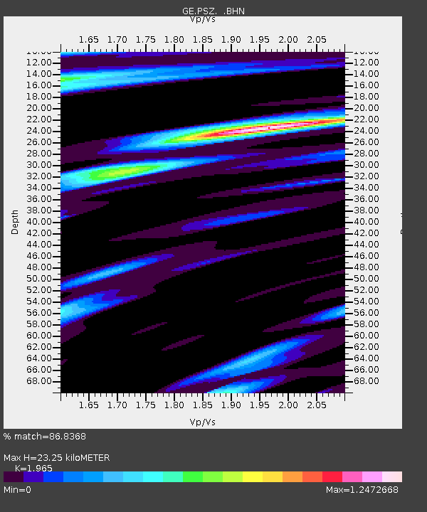
| Estimated Moho Depth: |
23.25 km |
| Estimated Crust Vp/Vs: |
1.97 |
| Assumed Crust Vp: |
6.155 km/s |
| Estimated Crust Vs: |
3.132 km/s |
| Estimated Crust Poisson's Ratio: |
0.33 |
|
| Radial Match: |
86.8368 % |
| Radial Bump: |
400 |
| Transverse Match: |
55.074497 % |
| Transverse Bump: |
400 |
| SOD ConfigId: |
2475 |
| Insert Time: |
2010-03-09 04:03:45.886 +0000 |
| GWidth: |
2.5 |
| Max Bumps: |
400 |
| Tol: |
0.001 |
|

Signal To Noise
| Channel | StoN | STA | LTA |
| GE:PSZ: :BHN:20050826T18:24:01.095006Z | 1.5009626 | 1.1495448E-7 | 7.658718E-8 |
| GE:PSZ: :BHE:20050826T18:24:01.095006Z | 2.544858 | 1.8649229E-7 | 7.3281996E-8 |
| GE:PSZ: :BHZ:20050826T18:24:01.095006Z | 3.0775936 | 2.8994316E-7 | 9.421099E-8 |
| Arrivals |
| Ps | 3.9 SECOND |
| PpPs | 11 SECOND |
| PsPs/PpSs | 14 SECOND |


